
Topografische Karte Dutywa
Interaktive Karte
Klicken Sie auf die Karte, um die Höhe anzuzeigen.
Über diese Karte
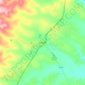
Name: Topografische Karte Dutywa, Höhe, Relief.
Durchschnittliche Höhe: 833 m
Minimale Höhe: 730 m
Maximale Höhe: 1.006 m
Andere topografische Karten
Klicken Sie auf eine Karte, um ihre Topografie, ihre Höhe und ihr Relief anzuzeigen.
Mbashe
South Africa > Eastern Cape > Amathole District Municipality > Mbhashe Local Municipality
Mbashe, Mbhashe Ward 21, Mbhashe Local Municipality, Amathole District Municipality, Eastern Cape, South Africa
Durchschnittliche Höhe: 66 m
Ngxutyana River
South Africa > Eastern Cape > Amathole District Municipality > Mbhashe Local Municipality
Ngxutyana River, Mbhashe Local Municipality, Amathole District Municipality, Eastern Cape, South Africa
Durchschnittliche Höhe: 88 m
Ngqatyana
South Africa > Eastern Cape > Amathole District Municipality > Mbhashe Local Municipality
Ngqatyana, Mbhashe Local Municipality, Amathole District Municipality, Eastern Cape, South Africa
Durchschnittliche Höhe: 268 m