
Topografische Karte Pine Hill
Interaktive Karte
Klicken Sie auf die Karte, um die Höhe anzuzeigen.
Über diese Karte
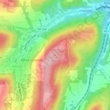
Name: Topografische Karte Pine Hill, Höhe, Relief.
Ort: Pine Hill, Allegany County, New York, 14803, USA (42.25696 -77.77810 42.25706 -77.77800)
Durchschnittliche Höhe: 567 m
Minimale Höhe: 479 m
Maximale Höhe: 671 m
Andere topografische Karten
Klicken Sie auf eine Karte, um ihre Topografie, ihre Höhe und ihr Relief anzuzeigen.
Trout River
Trout River, Franklin County, New York, 12926, USA
Durchschnittliche Höhe: 193 m
Graham
USA > New York > Town of Mount Pleasant > Graham
Graham, Town of Mount Pleasant, Westchester County, New York, 10532, USA
Durchschnittliche Höhe: 111 m
Flat Top Mountain
Flat Top Mountain, Franklin County, New York, USA
Durchschnittliche Höhe: 568 m
Livingston Island
Livingston Island, Town of Philipstown, Putnam County, New York, 10922, USA
Durchschnittliche Höhe: 156 m
Lake Champlain
Lake Champlain, Essex County, New York, USA
Durchschnittliche Höhe: 341 m
Boundary Peak
Boundary Peak, Essex County, New York, USA
Durchschnittliche Höhe: 1.175 m
Avalanche Lake
Avalanche Lake, Avalanche Pass Trail, Essex County, New York, USA
Durchschnittliche Höhe: 1.066 m
Roosevelt Island
USA > New York > New York City
Roosevelt Island, Manhattan Community Board 8, New York County, New York City, New York, 10044, USA
Durchschnittliche Höhe: 13 m
Falls Creek
Falls Creek, Town of Delhi, Delaware County, New York, 13753, USA
Durchschnittliche Höhe: 515 m
Midtown South
USA > New York > New York City
Midtown South, Manhattan, Manhattan Community Board 5, New York County, New York City, New York, 10118, USA
Durchschnittliche Höhe: 20 m
Farmingville
USA > New York > Farmingville
Farmingville, Suffolk County, New York, 11738, USA
Durchschnittliche Höhe: 47 m