
Topografische Karte Port Kelley
Interaktive Karte
Klicken Sie auf die Karte, um die Höhe anzuzeigen.
Über diese Karte
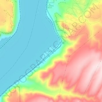
Name: Topografische Karte Port Kelley, Höhe, Relief.
Ort: Port Kelley, Walla Walla County, Washington, United States (46.00541 -118.95806 46.04541 -118.91806)
Durchschnittliche Höhe: 255 m
Minimale Höhe: 96 m
Maximale Höhe: 471 m
Andere topografische Karten
Klicken Sie auf eine Karte, um ihre Topografie, ihre Höhe und ihr Relief anzuzeigen.
Touchet
United States > Washington > Walla Walla County > Touchet
Touchet, Walla Walla County, Washington, 99360, United States
Durchschnittliche Höhe: 139 m
Whitman Mission National Historic Site
United States > Washington > Walla Walla County
Whitman Mission National Historic Site, Walla Walla County, Washington, United States
Durchschnittliche Höhe: 196 m
Walla Walla
United States > Washington > Walla Walla County > Walla Walla
Walla Walla, Walla Walla County, Washington, United States
Durchschnittliche Höhe: 297 m
Wallula
United States > Washington > Walla Walla County
Wallula, Walla Walla County, Washington, United States
Durchschnittliche Höhe: 119 m