
Topografische Karte Mount Stewart
Interaktive Karte
Klicken Sie auf die Karte, um die Höhe anzuzeigen.
Über diese Karte
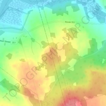
Name: Topografische Karte Mount Stewart, Höhe, Relief.
Ort: Mount Stewart, Kings County, Prince Edward Island, Canada (46.34714 -62.84404 46.37457 -62.83119)
Durchschnittliche Höhe: 38 m
Minimale Höhe: 0 m
Maximale Höhe: 81 m
Andere topografische Karten
Klicken Sie auf eine Karte, um ihre Topografie, ihre Höhe und ihr Relief anzuzeigen.
Monticello
Canada > Prince Edward Island > Kings County
Monticello, Kings County, Prince Edward Island, Canada
Durchschnittliche Höhe: 21 m
Milburn
Canada > Prince Edward Island > Kings County
Milburn, Kings County, Prince Edward Island, Canada
Durchschnittliche Höhe: 29 m
Town of Souris
Canada > Prince Edward Island > Kings County
Town of Souris, Kings County, Prince Edward Island, Canada
Durchschnittliche Höhe: 9 m
Cambridge
Canada > Prince Edward Island > Kings County
Cambridge, Kings County, Prince Edward Island, Canada
Durchschnittliche Höhe: 17 m
Cable Head East
Canada > Prince Edward Island > Kings County
Cable Head East, Kings County, Prince Edward Island, Canada
Durchschnittliche Höhe: 19 m
Georgetown
Canada > Prince Edward Island > Kings County
Georgetown, Town of Three Rivers, Kings County, Prince Edward Island, Canada
Durchschnittliche Höhe: 9 m
Canavoy
Canada > Prince Edward Island > Kings County
Canavoy, Kings County, Prince Edward Island, Canada
Durchschnittliche Höhe: 15 m
Morell
Canada > Prince Edward Island > Kings County
Morell, Rural Municipality of Morell, Kings County, Prince Edward Island, Canada
Durchschnittliche Höhe: 15 m
DeGros Marsh
Canada > Prince Edward Island > Kings County
DeGros Marsh, Town of Three Rivers, Kings County, Prince Edward Island, Canada
Durchschnittliche Höhe: 10 m
Cardigan
Canada > Prince Edward Island > Kings County
Cardigan, Town of Three Rivers, Kings County, Prince Edward Island, Canada
Durchschnittliche Höhe: 27 m
Saint Charles
Canada > Prince Edward Island > Kings County
Saint Charles, Kings County, Prince Edward Island, Canada
Durchschnittliche Höhe: 36 m
Roseneath
Canada > Prince Edward Island > Kings County
Roseneath, Town of Three Rivers, Kings County, Prince Edward Island, Canada
Durchschnittliche Höhe: 22 m
Souris
Canada > Prince Edward Island > Kings County > Souris
Souris, Kings County, Prince Edward Island, Canada
Durchschnittliche Höhe: 33 m
Alliston
Canada > Prince Edward Island > Kings County
Alliston, Kings County, Prince Edward Island, Canada
Durchschnittliche Höhe: 60 m
Poplar Point
Canada > Prince Edward Island > Kings County
Poplar Point, Rural Municipality of Central Kings, Kings County, Prince Edward Island, Canada
Durchschnittliche Höhe: 19 m
Lower Montague
Canada > Prince Edward Island > Kings County > Lower Montague
Lower Montague, Town of Three Rivers, Kings County, Prince Edward Island, C0A 1R0, Canada
Durchschnittliche Höhe: 15 m
Murray River
Canada > Prince Edward Island > Kings County > Murray River
Murray River, Kings County, Prince Edward Island, C0A 1W0, Canada
Durchschnittliche Höhe: 34 m
Prince Edward Island National Park
Canada > Prince Edward Island > Kings County > Greenwich
Prince Edward Island National Park, Greenwich Road, Greenwich, Kings County, Prince Edward Island, Canada
Durchschnittliche Höhe: 2 m