
Topografische Karte Mount Marcy
Interaktive Karte
Klicken Sie auf die Karte, um die Höhe anzuzeigen.
Über diese Karte
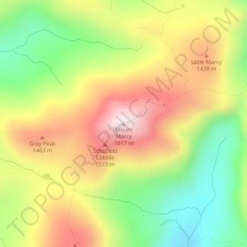
Name: Topografische Karte Mount Marcy, Höhe, Relief.
Durchschnittliche Höhe: 1.289 m
Minimale Höhe: 985 m
Maximale Höhe: 1.615 m
Mount Marcy (Mohawk: Tewawe’éstha) is the highest point in the U.S. state of New York, with an elevation of 5,343.1 feet (1,628.6 m). It is located in the Town of Keene in Essex County. The mountain is in the heart of the Adirondack High Peaks region of the High Peaks Wilderness Area. Its stature and expansive views make it a popular destination for hikers, who crowd its summit in the summer months.
Andere topografische Karten
Klicken Sie auf eine Karte, um ihre Topografie, ihre Höhe und ihr Relief anzuzeigen.
Cascade Mountain
United States > New York > Essex County > Town of Keene
Cascade Mountain, Cascade Mountain Trail, Town of Keene, Essex County, New York, United States
Durchschnittliche Höhe: 946 m