Topografische Karte Benbrook Lake
Klicken Sie auf die Karte, um die Höhe anzuzeigen.
Benbrook Lake
Construction of Benbrook dam began in May 1947, and was practically completed when floodgates were closed and deliberate impoundment was begun in September 1952. The cost to build the lake was $14.5 million ($112 million in 2007 dollars). The rolled-earth embankment is 9,130 feet (2,783 m) in length, including the concrete spillway, and rises 130 feet (39.6 m) above the streambed to an elevation of 747 feet (227.7 m) above sea level. A pair of 6.5-foot (2.0 m) × 13-foot (4.0 m) sliding gates operated by electric cable hoists controls the floodwater releases through the 13-foot-diameter conduit (4.0 m) . Two 30-inch-diameter pipes (0.76 m) are provided for low-flow releases to maintain downstream river flows. The concrete spillway for uncontrolled releases is 500 feet (152 m) long, with a 100-foot notch (30 m) in its center.
Über diese Karte
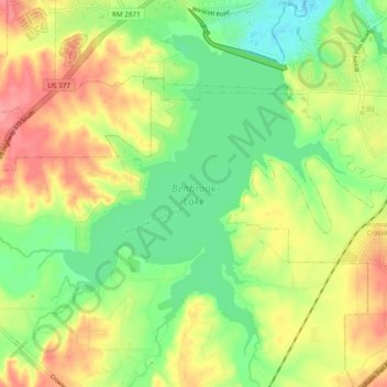
Name: Topografische Karte Benbrook Lake, Höhe, Relief.
Durchschnittliche Höhe: 230 m
Minimale Höhe: 191 m
Maximale Höhe: 276 m
Andere topografische Karten
Klicken Sie auf eine Karte, um ihre Topografie, ihre Höhe und ihr Relief anzuzeigen.



Summerfields/Chisholm Park
United States > Texas > Tarrant County > Fort Worth
Durchschnittliche Höhe: 203 m


Will Rogers Memorial Center
United States > Texas > Tarrant County > Fort Worth
Durchschnittliche Höhe: 181 m