Geolokalisieren

Topografische Karte Kosi

Interaktive Karte

Klicken Sie auf die Karte, um die Höhe anzuzeigen.

Über diese Karte

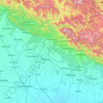
Name: Topografische Karte Kosi, Höhe, Relief.

Ort: Kosi, Uttarakhand, India (28.63392 78.94703 29.86158 79.64754)

Durchschnittliche Höhe: 603 m

Minimale Höhe: 176 m

Maximale Höhe: 2.681 m

The Kosi River catchment covers six geological and climatic belts varying in altitude from above 8,000 m (26,000 ft) to 95 m (312 ft) comprising the Tibetan plateau, the Himalayas, the Himalayan mid-hill belt, the Mahabharat Range, the Siwalik Hills and the Terai. The Dudh-Koshi sub-basin alone consists of 36 glaciers and 296 glacier lakes. The Kosi River basin borders the Tsangpo River basin in the north, the Mahananda River basin in the east, the Ganges Basin in the south and the Gandaki River basin in the west. The eight tributaries of the basin upstream the Chatra Gorge include from east to west:

Wikipedia (CC-BY-SA 3.0)

Andere topografische Karten

Klicken Sie auf eine Karte, um ihre Topografie, ihre Höhe und ihr Relief anzuzeigen.

Devprayag

India > Uttarakhand

Devprayag, Tehri Garhwal, Uttarakhand, India

Durchschnittliche Höhe: 1.249 m

Haridwar

India > Uttarakhand > Haridwar

Haridwar, Hardwar, Haridwar, Uttarakhand, 249401, India

Durchschnittliche Höhe: 360 m

Chamoli

India > Uttarakhand

Chamoli, Uttarakhand, India

Durchschnittliche Höhe: 3.712 m

Pithoragarh

India > Uttarakhand

Pithoragarh, Uttarakhand, 262500, India

Durchschnittliche Höhe: 1.316 m

Bageshwar

India > Uttarakhand

Bageshwar, Uttarakhand, India

Durchschnittliche Höhe: 2.409 m

Dehradun

India > Uttarakhand > Dehradun

Dehradun, Dehra Dūn, Dehradun, Uttarakhand, 248001, India

Durchschnittliche Höhe: 904 m

Shivling

India > Uttarakhand

Shivling, Uttarkashi, Uttarakhand, India

Durchschnittliche Höhe: 5.440 m

Pindar Glacier

India > Uttarakhand

Pindar Glacier, Bageshwar, Uttarakhand, India

Durchschnittliche Höhe: 4.447 m

Milam Glacier

India > Uttarakhand

Milam Glacier, Pithoragarh, Uttarakhand, India

Durchschnittliche Höhe: 5.223 m

Pithoragarh

India > Uttarakhand > Pithoragarh

Pithoragarh, Uttarakhand, 262500, India

Durchschnittliche Höhe: 1.618 m

Bāgeshwar

India > Uttarakhand > Bāgeshwar

Bāgeshwar, Bageshwar, Uttarakhand, 263642, India

Durchschnittliche Höhe: 1.154 m

Udham Singh Nagar

India > Uttarakhand

Udham Singh Nagar, Uttarakhand, India

Durchschnittliche Höhe: 521 m