
Topografische Karte Port Bannatyne
Interaktive Karte
Klicken Sie auf die Karte, um die Höhe anzuzeigen.
Über diese Karte
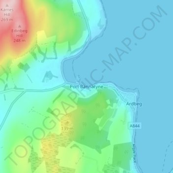
Name: Topografische Karte Port Bannatyne, Höhe, Relief.
Durchschnittliche Höhe: 52 m
Minimale Höhe: -3 m
Maximale Höhe: 267 m
Andere topografische Karten
Klicken Sie auf eine Karte, um ihre Topografie, ihre Höhe und ihr Relief anzuzeigen.
Iona
United Kingdom > Scotland > Argyll and Bute > The Village
Iona, The Village, Argyll and Bute, Scotland, United Kingdom
Durchschnittliche Höhe: 9 m
Sandbank
United Kingdom > Scotland > Argyll and Bute
Sandbank, Argyll and Bute, Scotland, PA23 8PJ, United Kingdom
Durchschnittliche Höhe: 100 m
Tiree
United Kingdom > Scotland > Argyll and Bute > Balevullin
Tiree, Balevullin, Argyll and Bute, Scotland, United Kingdom
Durchschnittliche Höhe: 3 m
Colonsay
United Kingdom > Scotland > Argyll and Bute > Scalasaig
Colonsay, Scalasaig, Argyll and Bute, Scotland, United Kingdom
Durchschnittliche Höhe: 11 m
Loch Etive
United Kingdom > Scotland > Argyll and Bute > Connel
Loch Etive, Connel, Argyll and Bute, Scotland, United Kingdom
Durchschnittliche Höhe: 318 m
Calgary
United Kingdom > Scotland > Argyll and Bute
Calgary, Argyll and Bute, Scotland, PA75 6QU, United Kingdom
Durchschnittliche Höhe: 109 m
Campbeltown
United Kingdom > Scotland > Argyll and Bute > Campbeltown
Campbeltown, Argyll and Bute, Scotland, PA28 6AD, United Kingdom
Durchschnittliche Höhe: 84 m
Rothesay
United Kingdom > Scotland > Argyll and Bute
Rothesay, Argyll and Bute, Scotland, PA20 2AA, United Kingdom
Durchschnittliche Höhe: 38 m
Staffa
United Kingdom > Scotland > Argyll and Bute
Staffa, Argyll and Bute, Scotland, United Kingdom
Durchschnittliche Höhe: 0 m
North Connel
United Kingdom > Scotland > Argyll and Bute
North Connel, Argyll and Bute, Scotland, PA37 1PL, United Kingdom
Durchschnittliche Höhe: 19 m
Tobermory
United Kingdom > Scotland > Argyll and Bute
Tobermory, Argyll and Bute, Scotland, United Kingdom
Durchschnittliche Höhe: 58 m