
Topografische Karte Biscayne Canal
Interaktive Karte
Klicken Sie auf die Karte, um die Höhe anzuzeigen.
Über diese Karte
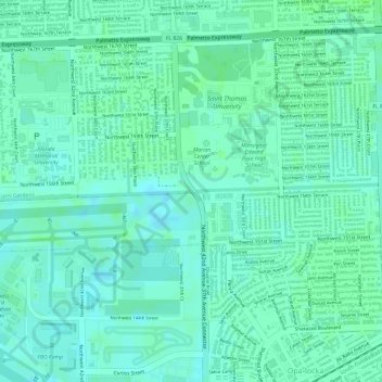
Name: Topografische Karte Biscayne Canal, Höhe, Relief.
Durchschnittliche Höhe: 7 m
Minimale Höhe: 2 m
Maximale Höhe: 10 m
Andere topografische Karten
Klicken Sie auf eine Karte, um ihre Topografie, ihre Höhe und ihr Relief anzuzeigen.
St. Johns River
St. Johns River, Lake County, Florida, 32203, USA
Durchschnittliche Höhe: 13 m
Miramar Beach
USA > Florida > Miramar Beach
Miramar Beach, Walton County, Florida, 32550, USA
Durchschnittliche Höhe: 3 m
Banana River
Banana River, Brevard County, Florida, 32920, USA
Durchschnittliche Höhe: 2 m
Kendale Lakes
USA > Florida > Kendale Lakes
Kendale Lakes, Miami-Dade County, Florida, 33183, USA
Durchschnittliche Höhe: 6 m
Century Village
USA > Florida > Century Village
Century Village, Palm Beach County, Florida, 33417, USA
Durchschnittliche Höhe: 9 m
St. Augustine
USA > Florida > St. Augustine
St. Augustine, St. Johns County, Florida, 32084, USA
Durchschnittliche Höhe: 5 m
Scott Lake
USA > Florida > Scott Lake
Scott Lake, Miami-Dade County, Florida, 33056-3105, USA
Durchschnittliche Höhe: 7 m
1388
USA > Florida > Boca Raton
1388, Boca Raton, Palm Beach County, Florida, 33432, USA
Durchschnittliche Höhe: 4 m
Oriole Park
Oriole Park, Margate, Broward County, Florida, USA
Durchschnittliche Höhe: 6 m
Stoer Island
Stoer Island, Leesburg, Lake County, Florida, 34748, USA
Durchschnittliche Höhe: 26 m
Copeland Park
Copeland Park, Sulphur Springs, Tampa, Hillsborough County, Florida, USA
Durchschnittliche Höhe: 15 m
Rainbow Park
USA > Florida > Rainbow Park
Rainbow Park, Marion County, Florida, USA
Durchschnittliche Höhe: 31 m
Dry Tortugas National Park
Dry Tortugas National Park, Monroe County, Florida, USA
Durchschnittliche Höhe: 0 m
Georges Island
Georges Island, Brevard County, Florida, 32932, USA
Durchschnittliche Höhe: 5 m
Daisy Lake
USA > Florida > Daisy Lake
Daisy Lake, Volusia County, Florida, 32720, USA
Durchschnittliche Höhe: 6 m
Dawson Island
USA > Florida > Jacksonville
Dawson Island, Jacksonville, Duval County, Florida, USA
Durchschnittliche Höhe: 2 m
Bradfordville
USA > Florida > Bradfordville
Bradfordville, Leon County, Florida, 32312, USA
Durchschnittliche Höhe: 51 m