
Spenden
Rüste dich für dein nächstes Abenteuer:
Als Amazon-Partner verdient diese Website an qualifizierten Käufen, ohne zusätzliche Kosten für Sie.
Topografische Karte Banisilan
Klicken Sie auf die Karte, um die Höhe anzuzeigen.
Spenden
Rüste dich für dein nächstes Abenteuer:
Als Amazon-Partner verdient diese Website an qualifizierten Käufen, ohne zusätzliche Kosten für Sie.
Über diese Karte
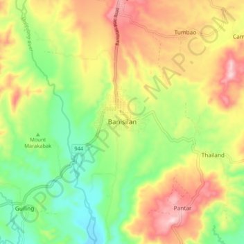
Name: Topografische Karte Banisilan, Höhe, Relief.
Ort: Banisilan, Cotabato, Soccsksargen, Philippines (7.46408 124.65463 7.54408 124.73463)
Durchschnittliche Höhe: 392 m
Minimale Höhe: 228 m
Maximale Höhe: 593 m
Spenden
Rüste dich für dein nächstes Abenteuer:
Als Amazon-Partner verdient diese Website an qualifizierten Käufen, ohne zusätzliche Kosten für Sie.
Andere topografische Karten
Klicken Sie auf eine Karte, um ihre Topografie, ihre Höhe und ihr Relief anzuzeigen.
Kidapawan
Located in Kidapawan is the Paniki Falls Eco-River Park located at Umpan Village, Barangay Balabag. Kidapawan is also one of the most well-known starting points for trekking on Mount Apo via the city's Lake Agco in Barangay Ilomavis, Kidapawan-Santa Cruz, and Kidapawan-Magpet trails which towers at 10,311 feet…
Durchschnittliche Höhe: 495 m
Magpet
Rice production in Magpet is only 1.16% or 1,028 hectares of the total land area with another 1.50% or 1,115 hectares as potential area due to its land topography, which is mostly hilly or mountainous.
Durchschnittliche Höhe: 597 m
Spenden
Rüste dich für dein nächstes Abenteuer:
Als Amazon-Partner verdient diese Website an qualifizierten Käufen, ohne zusätzliche Kosten für Sie.
Antipas
Temperature ranges from 23 to 32 degrees Celsius, because of its topographic elevation of 320 meters above sea level and proximity to mountainous Bukidnon province, making it one of the cool places in Soccsksargen. The highest temperature is felt during the months of March and April, while the lowest is in…
Durchschnittliche Höhe: 297 m
Kabacan
The landscape is characterized by almost regular landscape of flat terrain. The high mountains and rolling hills leaping close to the river plus the narrow plains have varied topographical features. Other features are moderately sloping and strongly sloping.
Durchschnittliche Höhe: 95 m
Spenden
Rüste dich für dein nächstes Abenteuer:
Als Amazon-Partner verdient diese Website an qualifizierten Käufen, ohne zusätzliche Kosten für Sie.
Spenden
Rüste dich für dein nächstes Abenteuer:
Als Amazon-Partner verdient diese Website an qualifizierten Käufen, ohne zusätzliche Kosten für Sie.
Spenden
Rüste dich für dein nächstes Abenteuer:
Als Amazon-Partner verdient diese Website an qualifizierten Käufen, ohne zusätzliche Kosten für Sie.
Kidapawan
Located in Kidapawan is the Paniki Falls Eco-River Park located at Umpan Village, Barangay Balabag. Kidapawan is also one of the most well-known starting points for trekking on Mount Apo via the city's Lake Agco in Barangay Ilomavis, Kidapawan-Santa Cruz, and Kidapawan-Magpet trails which towers at 10,311 feet…
Durchschnittliche Höhe: 495 m
Spenden
Rüste dich für dein nächstes Abenteuer:
Als Amazon-Partner verdient diese Website an qualifizierten Käufen, ohne zusätzliche Kosten für Sie.