
Spenden
Rüste dich für dein nächstes Abenteuer:
Als Amazon-Partner verdient diese Website an qualifizierten Käufen, ohne zusätzliche Kosten für Sie.
Topografische Karte Alta Sierra
Klicken Sie auf die Karte, um die Höhe anzuzeigen.
Spenden
Rüste dich für dein nächstes Abenteuer:
Als Amazon-Partner verdient diese Website an qualifizierten Käufen, ohne zusätzliche Kosten für Sie.
Alta Sierra
Alta Sierra was laid out by property developers in the 1960s. Alta Sierra is a golf course community, with homes built around the Alta Sierra Country Club, a semi-private 18 hole course built in 1964. The community has a member-owned airport with a 2800 foot runway. The community is located just east of California State Highway 49, at an elevation of approximately 2300 feet, between the cities of Grass Valley, California to the north and Auburn, California to the south. There is a small commercial district with several restaurants, a gas station, a market and personal service businesses. There is also an elementary school and a motel.
Spenden
Rüste dich für dein nächstes Abenteuer:
Als Amazon-Partner verdient diese Website an qualifizierten Käufen, ohne zusätzliche Kosten für Sie.
Über diese Karte
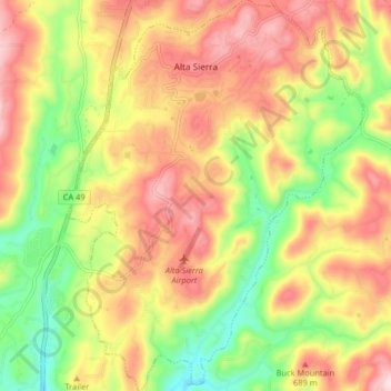
Name: Topografische Karte Alta Sierra, Höhe, Relief.
Ort: Alta Sierra, Nevada County, California, United States (39.08918 -121.08055 39.15229 -121.01878)
Durchschnittliche Höhe: 603 m
Minimale Höhe: 449 m
Maximale Höhe: 747 m
Spenden
Rüste dich für dein nächstes Abenteuer:
Als Amazon-Partner verdient diese Website an qualifizierten Käufen, ohne zusätzliche Kosten für Sie.