
Topografische Karte Northport
Interaktive Karte
Klicken Sie auf die Karte, um die Höhe anzuzeigen.
Über diese Karte
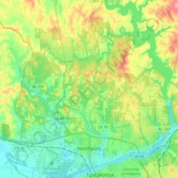
Name: Topografische Karte Northport, Höhe, Relief.
Ort: Northport, Tuscaloosa County, Alabama, United States (33.20712 -87.67779 33.34008 -87.54262)
Durchschnittliche Höhe: 82 m
Minimale Höhe: 35 m
Maximale Höhe: 173 m
Andere topografische Karten
Klicken Sie auf eine Karte, um ihre Topografie, ihre Höhe und ihr Relief anzuzeigen.
The Summit
United States > Alabama > Tuscaloosa County > Northport
The Summit, Northport, Tuscaloosa County, Alabama, 35473, United States
Durchschnittliche Höhe: 69 m
Northbrook
United States > Alabama > Tuscaloosa County > Northport
Northbrook, Northport, Tuscaloosa County, Alabama, 35476, United States
Durchschnittliche Höhe: 70 m
Clear Creek Colony
United States > Alabama > Tuscaloosa County > Northport > Clear Creek Colony
Clear Creek Colony, Northport, Tuscaloosa County, Alabama, 35473, United States
Durchschnittliche Höhe: 93 m