
Topografische Karte Brewster County
Interaktive Karte
Klicken Sie auf die Karte, um die Höhe anzuzeigen.
Über diese Karte
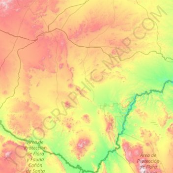
Name: Topografische Karte Brewster County, Höhe, Relief.
Ort: Brewster County, Texas, USA (28.97153 -103.80075 30.66585 -102.32085)
Durchschnittliche Höhe: 1.139 m
Minimale Höhe: 464 m
Maximale Höhe: 2.631 m
Andere topografische Karten
Klicken Sie auf eine Karte, um ihre Topografie, ihre Höhe und ihr Relief anzuzeigen.
Silver Valley
USA > Texas > Silver Valley
Silver Valley, Coleman County, Texas, USA
Durchschnittliche Höhe: 609 m
Twin Mountains
USA > Texas > Twin Mountains
Twin Mountains, Young County, Texas, 76450, USA
Durchschnittliche Höhe: 329 m
PROFESSIONAL COMMUNICATIONS
PROFESSIONAL COMMUNICATIONS, West 25th Street, Cottage, West Odessa, Ector County, Texas, 79763, USA
Durchschnittliche Höhe: 897 m
Nelson City
USA > Texas > Nelson City
Nelson City, Kendall County, Texas, USA
Durchschnittliche Höhe: 485 m
Karnes City
USA > Texas > Karnes City
Karnes City, Karnes County, Texas, 78118, USA
Durchschnittliche Höhe: 122 m
Ingleside on the Bay
USA > Texas > Ingleside on the Bay
Ingleside on the Bay, San Patricio County, Texas, USA
Durchschnittliche Höhe: 4 m
Post Oak Ridge
USA > Texas > Lago Vista
Post Oak Ridge, Lago Vista, Travis County, Texas, 78645, USA
Durchschnittliche Höhe: 314 m
Guadalupe Peak
Guadalupe Peak, Culberson County, Texas, 79847, USA
Durchschnittliche Höhe: 2.151 m
Owl Creek Mountains
Owl Creek Mountains, Bell County, Texas, USA
Durchschnittliche Höhe: 230 m