
Topografische Karte Manorhamilton Municipal District
Interaktive Karte
Klicken Sie auf die Karte, um die Höhe anzuzeigen.
Über diese Karte
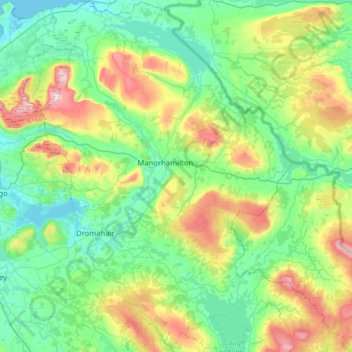
Name: Topografische Karte Manorhamilton Municipal District, Höhe, Relief.
Durchschnittliche Höhe: 156 m
Minimale Höhe: -1 m
Maximale Höhe: 641 m
Andere topografische Karten
Klicken Sie auf eine Karte, um ihre Topografie, ihre Höhe und ihr Relief anzuzeigen.
Acres
Acres, Aghavas ED, Ballinamore Municipal District, County Leitrim, Connacht, Ireland
Durchschnittliche Höhe: 74 m
Keshcarrigan
Keshcarrigan, Ballinamore Municipal District, County Leitrim, Connacht, Ireland
Durchschnittliche Höhe: 78 m
Blackmountain
Blackmountain, Munakill ED, Manorhamilton Municipal District, County Leitrim, Connacht, Ireland
Durchschnittliche Höhe: 234 m
Ballinamore Municipal District
Ballinamore Municipal District, County Leitrim, Connacht, Ireland
Durchschnittliche Höhe: 109 m
Moher (Gregg)
Moher (Gregg), Moher ED, Ballinamore Municipal District, County Leitrim, Connacht, Ireland
Durchschnittliche Höhe: 233 m