
Spenden
Rüste dich für dein nächstes Abenteuer:
Als Amazon-Partner verdient diese Website an qualifizierten Käufen, ohne zusätzliche Kosten für Sie.
Topografische Karte Surat
Klicken Sie auf die Karte, um die Höhe anzuzeigen.
Spenden
Rüste dich für dein nächstes Abenteuer:
Als Amazon-Partner verdient diese Website an qualifizierten Käufen, ohne zusätzliche Kosten für Sie.
Surat
Surat is a port city situated on the banks of the Tapi river. After dams were built, water flow in Tapi deceased causing the original port facilities to close. The nearest port is now in the Magadalla and Hazira area of Surat Metropolitan Region. It has a famous beach called 'Dumas Beach' located in Dumas.The city is located at 21°12′18″N 72°50′24″E / 21.205°N 72.840°E / 21.205; 72.840. It has an average elevation of 13 metres. The Surat district is surrounded by the Bharuch, Narmada, Navsari and Tapi districts, and Gulf of Cambay to the west. The climate is tropical and monsoon rainfall is abundant. According to the Bureau of Indian Standards, the town falls under seismic zone-III, in a scale of I to V (in order of increasing vulnerability to earthquakes).
Spenden
Rüste dich für dein nächstes Abenteuer:
Als Amazon-Partner verdient diese Website an qualifizierten Käufen, ohne zusätzliche Kosten für Sie.
Über diese Karte
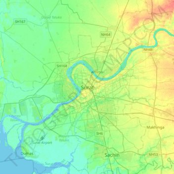
Name: Topografische Karte Surat, Höhe, Relief.
Ort: Surat, Katargam Taluka, Surat, Gujarat, 395008, India (21.04949 72.67171 21.36949 72.99171)
Durchschnittliche Höhe: 13 m
Minimale Höhe: -3 m
Maximale Höhe: 38 m
Spenden
Rüste dich für dein nächstes Abenteuer:
Als Amazon-Partner verdient diese Website an qualifizierten Käufen, ohne zusätzliche Kosten für Sie.