
Topografische Karte College Park
Interaktive Karte
Klicken Sie auf die Karte, um die Höhe anzuzeigen.
Über diese Karte
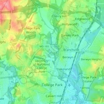
Name: Topografische Karte College Park, Höhe, Relief.
Durchschnittliche Höhe: 38 m
Minimale Höhe: 10 m
Maximale Höhe: 100 m
The Lakeland neighborhood was developed beginning in 1892 around the Baltimore and Ohio Railroad, whose Branchville and Calvert Road depots were located approximately one mile to the north and south, respectively. Lakeland was created by Edwin Newman, who improved the original 238 acres (0.96 km2) located to the west of the railroad. He also built a number of the original homes, a small town hall, and a general store. The area was originally envisioned as a resort-type community. However, due to the flood-prone, low-lying topography, the neighborhood attracted a lower-income population and became an area for African-American settlement. Around 1900, the Baltimore Gold Fish Company built five artificial lakes in the area to spawn goldfish and rare species of fish. A one-room school was built in 1903 for the African-American population; a new school was built in 1925.
Andere topografische Karten
Klicken Sie auf eine Karte, um ihre Topografie, ihre Höhe und ihr Relief anzuzeigen.
National Harbor
United States > Maryland > Prince George's County
National Harbor, Prince George's County, Maryland, 20745, United States
Durchschnittliche Höhe: 24 m
Greenbelt Park
United States > Maryland > Prince George's County > Greenbelt
Greenbelt Park, 6565, Greenbelt, Prince George's County, Maryland, 20770, United States
Durchschnittliche Höhe: 40 m
Temple Hills
United States > Maryland > Prince George's County
Temple Hills, Prince George's County, Maryland, 20748, United States
Durchschnittliche Höhe: 66 m
Upper Marlboro
United States > Maryland > Prince George's County
Upper Marlboro, Prince George's County, Maryland, United States
Durchschnittliche Höhe: 19 m
Sellman Estates
United States > Maryland > Prince George's County > Beltsville
Sellman Estates, Beltsville, Prince George's County, Maryland, 20705, United States
Durchschnittliche Höhe: 61 m
White Hall
United States > Maryland > Prince George's County
White Hall, Prince George's County, Maryland, 20607, United States
Durchschnittliche Höhe: 36 m
Summerfield
United States > Maryland > Prince George's County
Summerfield, Prince George's County, Maryland, 20785, United States
Durchschnittliche Höhe: 49 m
Langley Park
United States > Maryland > Prince George's County
Langley Park, Prince George's County, Maryland, 20783, United States
Durchschnittliche Höhe: 53 m
Brandywine
United States > Maryland > Prince George's County
Brandywine, Prince George's County, Maryland, 20613, United States
Durchschnittliche Höhe: 61 m
Suitland
United States > Maryland > Prince George's County
Suitland, Prince George's County, Maryland, 20233, United States
Durchschnittliche Höhe: 70 m
Camp Springs
United States > Maryland > Prince George's County > Camp Springs
Camp Springs, Prince George's County, Maryland, 20746, United States
Durchschnittliche Höhe: 72 m
Landover
United States > Maryland > Prince George's County > Landover
Landover, Prince George's County, Maryland, 20785, United States
Durchschnittliche Höhe: 38 m
Cheverly
United States > Maryland > Prince George's County
Cheverly, Prince George's County, Maryland, United States
Durchschnittliche Höhe: 29 m
Buck Lodge
United States > Maryland > Prince George's County > Adelphi
Buck Lodge, Adelphi, Prince George's County, Maryland, 20993, United States
Durchschnittliche Höhe: 59 m
Capitol Heights
United States > Maryland > Prince George's County
Capitol Heights, Prince George's County, Maryland, United States
Durchschnittliche Höhe: 64 m
Mitchellville
United States > Maryland > Prince George's County > Mitchellville
Mitchellville, Prince George's County, Maryland, United States
Durchschnittliche Höhe: 46 m
Lanham
United States > Maryland > Prince George's County > Glenn Dale
Lanham, Glenn Dale, Prince George's County, Maryland, 20706, United States
Durchschnittliche Höhe: 47 m
Seabrook
United States > Maryland > Prince George's County > Glenn Dale
Seabrook, Glenn Dale, Prince George's County, Maryland, 20070, United States
Durchschnittliche Höhe: 49 m
Konterra
United States > Maryland > Prince George's County > Konterra
Konterra, Prince George's County, Maryland, United States
Durchschnittliche Höhe: 86 m
Hyattsville
United States > Maryland > Prince George's County
Hyattsville, Prince George's County, Maryland, 20782, United States
Durchschnittliche Höhe: 24 m
Auburn
United States > Maryland > Prince George's County > Auburn
Auburn, Prince George's County, Maryland, 2060, United States
Durchschnittliche Höhe: 36 m
Silesia
United States > Maryland > Prince George's County > Silesia
Silesia, Prince George's County, Maryland, 20744, United States
Durchschnittliche Höhe: 27 m
Farmington Road Estates
United States > Maryland > Prince George's County > Farmington Road Estates
Farmington Road Estates, Prince George's County, Maryland, 2060, United States
Durchschnittliche Höhe: 47 m
Mount Rainier Neighborhood Park
United States > Maryland > Prince George's County > Mount Rainier
Mount Rainier Neighborhood Park, Queenstown, Mount Rainier, Prince George's County, Maryland, 20712, United States
Durchschnittliche Höhe: 21 m
Adelphi
United States > Maryland > Prince George's County
Adelphi, Prince George's County, Maryland, United States
Durchschnittliche Höhe: 56 m
Bowie
United States > Maryland > Prince George's County > Bowie
Bowie, Prince George's County, Maryland, United States
Durchschnittliche Höhe: 38 m
Laurel
United States > Maryland > Prince George's County
Laurel, Prince George's County, Maryland, 20707, United States
Durchschnittliche Höhe: 73 m