
Topografische Karte Erie Lake
Interaktive Karte
Klicken Sie auf die Karte, um die Höhe anzuzeigen.
Über diese Karte
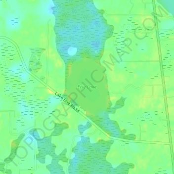
Name: Topografische Karte Erie Lake, Höhe, Relief.
Ort: Erie Lake, Lake County, Florida, United States (28.47280 -81.85250 28.48213 -81.84497)
Durchschnittliche Höhe: 34 m
Minimale Höhe: 25 m
Maximale Höhe: 43 m
Andere topografische Karten
Klicken Sie auf eine Karte, um ihre Topografie, ihre Höhe und ihr Relief anzuzeigen.
Clermont
United States > Florida > Lake County
Clermont, Lake County, Florida, 32711, United States
Durchschnittliche Höhe: 38 m
Groveland
United States > Florida > Lake County
Groveland, Lake County, Florida, United States
Durchschnittliche Höhe: 32 m
Mount Plymouth
United States > Florida > Lake County
Mount Plymouth, Lake County, Florida, 32776, United States
Durchschnittliche Höhe: 25 m
Sugarloaf Mountain
United States > Florida > Lake County
Sugarloaf Mountain, Lake County, Florida, 34715, United States
Durchschnittliche Höhe: 55 m
Jacks Lake
United States > Florida > Lake County > Clermont
Jacks Lake, Clermont, Lake County, Florida, United States
Durchschnittliche Höhe: 54 m
Tavares
United States > Florida > Lake County > Tavares
Tavares, Lake County, Florida, 32278, United States
Durchschnittliche Höhe: 22 m
Leesburg
United States > Florida > Lake County
Leesburg, Lake County, Florida, 34762, United States
Durchschnittliche Höhe: 26 m
Lake Louisa
United States > Florida > Lake County
Lake Louisa, Lake County, Florida, United States
Durchschnittliche Höhe: 31 m
Grand Island
United States > Florida > Lake County > Grand Island
Grand Island, Lake County, Florida, 32735, United States
Durchschnittliche Höhe: 25 m
Howey-in-the-Hills
United States > Florida > Lake County
Howey-in-the-Hills, Lake County, Florida, 34737, United States
Durchschnittliche Höhe: 25 m