
Topografische Karte Capelas
Interaktive Karte
Klicken Sie auf die Karte, um die Höhe anzuzeigen.
Über diese Karte
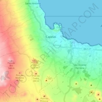
Name: Topografische Karte Capelas, Höhe, Relief.
Ort: Capelas, Ponta Delgada, Azores, Portugal (37.80425 -25.75047 37.85171 -25.66940)
Durchschnittliche Höhe: 195 m
Minimale Höhe: 0 m
Maximale Höhe: 588 m
The first settlements congregated around the port of Poços, along the northern edge that divides Capelas from São Vicente Ferreira; its first settlers establishing shelters in and around the 16th Century. With elevation of Capelas to (religious) parish it became integrated within the municipality of Ponta Delgada (on 11 July 1592). This administrative dependency lasted until it was elevated to status of vila, as stipulated by the Carta de Lei (Charter Law) conferred by Queen D. Maria, on July 10, 1839.
Andere topografische Karten
Klicken Sie auf eine Karte, um ihre Topografie, ihre Höhe und ihr Relief anzuzeigen.
São Vicente Ferreira
Portugal > Ponta Delgada > São Vicente Ferreira
São Vicente Ferreira, Ponta Delgada, Azores, Portugal
Durchschnittliche Höhe: 152 m