
Topografische Karte Le Vougot
Interaktive Karte
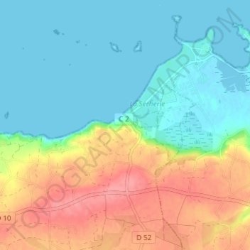
Klicken Sie auf die Karte, um die Höhe anzuzeigen.
Über diese Karte
Name: Topografische Karte Le Vougot, Höhe, Relief.
Durchschnittliche Höhe: 27 m
Minimale Höhe: -1 m
Maximale Höhe: 78 m
Andere topografische Karten
Klicken Sie auf eine Karte, um ihre Topografie, ihre Höhe und ihr Relief anzuzeigen.
Kerizog
France > Bretagne > Finistère > Plouguerneau
Kerizog, Plouguerneau, Brest, Finistère, Bretagne, France métropolitaine, 29880, France
Durchschnittliche Höhe: 31 m
Mezeozen
France > Bretagne > Finistère > Plouguerneau
Mezeozen, Plouguerneau, Brest, Finistère, Bretagne, France métropolitaine, 29880, France
Durchschnittliche Höhe: 36 m
Kervily
France > Bretagne > Finistère > Plouguerneau
Kervily, Plouguerneau, Brest, Finistère, Bretagne, France métropolitaine, 29880, France
Durchschnittliche Höhe: 34 m
Île Vierge
France > Bretagne > Finistère > Plouguerneau
Île Vierge, Plouguerneau, Brest, Finistère, Bretagne, France métropolitaine, 29880, France
Durchschnittliche Höhe: 0 m
Le Cosquer
France > Bretagne > Finistère > Plouguerneau > Le Cosquer
Le Cosquer, Plouguerneau, Brest, Finistère, Bretagne, France métropolitaine, 29880, France
Durchschnittliche Höhe: 51 m
Kerhuel
France > Bretagne > Finistère > Plouguerneau
Kerhuel, Plouguerneau, Brest, Finistère, Bretagne, France métropolitaine, 29880, France
Durchschnittliche Höhe: 52 m
Kergonvel
France > Bretagne > Finistère > Plouguerneau
Kergonvel, Plouguerneau, Brest, Finistère, Bretagne, France métropolitaine, 29880, France
Durchschnittliche Höhe: 37 m