
Topografische Karte Siedlec
Interaktive Karte
Klicken Sie auf die Karte, um die Höhe anzuzeigen.
Über diese Karte
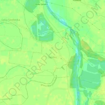
Name: Topografische Karte Siedlec, Höhe, Relief.
Durchschnittliche Höhe: 184 m
Minimale Höhe: 173 m
Maximale Höhe: 188 m
Andere topografische Karten
Klicken Sie auf eine Karte, um ihre Topografie, ihre Höhe und ihr Relief anzuzeigen.
Piotrkowice
Poland > Lesser Poland Voivodeship > Tarnów County
Piotrkowice, gmina Tuchów, Tarnów County, Lesser Poland Voivodeship, Poland
Durchschnittliche Höhe: 286 m
Dwudniaki
Poland > Lesser Poland Voivodeship > Tarnów County > Wierzchosławice
Dwudniaki, Wierzchosławice, gmina Wierzchosławice, Tarnów County, Lesser Poland Voivodeship, 33-122, Poland
Durchschnittliche Höhe: 192 m
Skała
Poland > Lesser Poland Voivodeship > Tarnów County > Koszyce Małe
Skała, Koszyce Małe, gmina Tarnów, Tarnów County, Lesser Poland Voivodeship, 33-111, Poland
Durchschnittliche Höhe: 231 m
Żabno
Poland > Lesser Poland Voivodeship > Tarnów County
Żabno, gmina Żabno, Tarnów County, Lesser Poland Voivodeship, 33-240, Poland
Durchschnittliche Höhe: 186 m