
Topografische Karte Winter Park
Interaktive Karte
Klicken Sie auf die Karte, um die Höhe anzuzeigen.
Über diese Karte
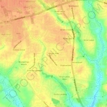
Name: Topografische Karte Winter Park, Höhe, Relief.
Durchschnittliche Höhe: 58 m
Minimale Höhe: 33 m
Maximale Höhe: 71 m
Andere topografische Karten
Klicken Sie auf eine Karte, um ihre Topografie, ihre Höhe und ihr Relief anzuzeigen.
The Greens
United States > North Carolina > Cumberland County > Fayetteville
The Greens, Fayetteville, Cumberland County, North Carolina, 28311, United States
Durchschnittliche Höhe: 52 m
Hillendale
United States > North Carolina > Cumberland County > Fayetteville
Hillendale, Fayetteville, Cumberland County, North Carolina, 28311, United States
Durchschnittliche Höhe: 61 m
Williams Village
United States > North Carolina > Cumberland County > Fayetteville
Williams Village, Fayetteville, Cumberland County, North Carolina, 28301, United States
Durchschnittliche Höhe: 30 m