
Spenden
Rüste dich für dein nächstes Abenteuer:
Als Amazon-Partner verdient diese Website an qualifizierten Käufen, ohne zusätzliche Kosten für Sie.
Topografische Karte Elston
Klicken Sie auf die Karte, um die Höhe anzuzeigen.
Spenden
Rüste dich für dein nächstes Abenteuer:
Als Amazon-Partner verdient diese Website an qualifizierten Käufen, ohne zusätzliche Kosten für Sie.
Über diese Karte
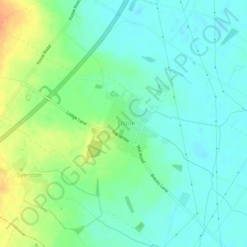
Name: Topografische Karte Elston, Höhe, Relief.
Durchschnittliche Höhe: 24 m
Minimale Höhe: 11 m
Maximale Höhe: 49 m
Spenden
Rüste dich für dein nächstes Abenteuer:
Als Amazon-Partner verdient diese Website an qualifizierten Käufen, ohne zusätzliche Kosten für Sie.
Andere topografische Karten
Klicken Sie auf eine Karte, um ihre Topografie, ihre Höhe und ihr Relief anzuzeigen.
Newark on Trent
United Kingdom > England > Nottinghamshire > Newark and Sherwood
Durchschnittliche Höhe: 18 m
Averham CP
United Kingdom > England > Nottinghamshire > Newark and Sherwood
Durchschnittliche Höhe: 23 m
Southwell CP
United Kingdom > England > Nottinghamshire > Newark and Sherwood
Durchschnittliche Höhe: 47 m
Spenden
Rüste dich für dein nächstes Abenteuer:
Als Amazon-Partner verdient diese Website an qualifizierten Käufen, ohne zusätzliche Kosten für Sie.
Oxton CP
United Kingdom > England > Nottinghamshire > Newark and Sherwood
Durchschnittliche Höhe: 86 m
South Clifton
United Kingdom > England > Nottinghamshire > Newark and Sherwood
Durchschnittliche Höhe: 8 m
Ollerton
United Kingdom > England > Nottinghamshire > Newark and Sherwood
Durchschnittliche Höhe: 59 m
Spenden
Rüste dich für dein nächstes Abenteuer:
Als Amazon-Partner verdient diese Website an qualifizierten Käufen, ohne zusätzliche Kosten für Sie.
Rolleston CP
United Kingdom > England > Nottinghamshire > Newark and Sherwood
Durchschnittliche Höhe: 16 m
Clipstone
United Kingdom > England > Nottinghamshire > Newark and Sherwood
Durchschnittliche Höhe: 89 m
Rufford CP
United Kingdom > England > Nottinghamshire > Newark and Sherwood
Durchschnittliche Höhe: 76 m
Balderton
United Kingdom > England > Nottinghamshire > Newark and Sherwood > Balderton
Durchschnittliche Höhe: 20 m
Spenden
Rüste dich für dein nächstes Abenteuer:
Als Amazon-Partner verdient diese Website an qualifizierten Käufen, ohne zusätzliche Kosten für Sie.
Egmanton CP
United Kingdom > England > Nottinghamshire > Newark and Sherwood
Durchschnittliche Höhe: 50 m
Staythorpe CP
United Kingdom > England > Nottinghamshire > Newark and Sherwood
The land is very low-lying and level, varying little in elevation between 12–14 metres (39–46 ft) throughout.
Durchschnittliche Höhe: 16 m
Eakring CP
United Kingdom > England > Nottinghamshire > Newark and Sherwood
Durchschnittliche Höhe: 75 m
Spenden
Rüste dich für dein nächstes Abenteuer:
Als Amazon-Partner verdient diese Website an qualifizierten Käufen, ohne zusätzliche Kosten für Sie.
Blidworth Bottoms
United Kingdom > England > Nottinghamshire > Newark and Sherwood > Blidworth CP
Durchschnittliche Höhe: 107 m
East Stoke
United Kingdom > England > Nottinghamshire > Newark and Sherwood
Durchschnittliche Höhe: 24 m
Spenden
Rüste dich für dein nächstes Abenteuer:
Als Amazon-Partner verdient diese Website an qualifizierten Käufen, ohne zusätzliche Kosten für Sie.
Kelham CP
United Kingdom > England > Nottinghamshire > Newark and Sherwood > Newark on Trent
Durchschnittliche Höhe: 23 m
Caunton CP
United Kingdom > England > Nottinghamshire > Newark and Sherwood
Durchschnittliche Höhe: 42 m
Spenden
Rüste dich für dein nächstes Abenteuer:
Als Amazon-Partner verdient diese Website an qualifizierten Käufen, ohne zusätzliche Kosten für Sie.
Gonalston CP
United Kingdom > England > Nottinghamshire > Newark and Sherwood
Durchschnittliche Höhe: 42 m
Upton CP
United Kingdom > England > Nottinghamshire > Newark and Sherwood
Durchschnittliche Höhe: 30 m
Ompton CP
United Kingdom > England > Nottinghamshire > Newark and Sherwood
Durchschnittliche Höhe: 79 m
Clipstone
United Kingdom > England > Nottinghamshire > Newark and Sherwood
Durchschnittliche Höhe: 94 m
Spenden
Rüste dich für dein nächstes Abenteuer:
Als Amazon-Partner verdient diese Website an qualifizierten Käufen, ohne zusätzliche Kosten für Sie.
Kirton CP
United Kingdom > England > Nottinghamshire > Newark and Sherwood
Durchschnittliche Höhe: 55 m
Collingham CP
United Kingdom > England > Nottinghamshire > Newark and Sherwood
Durchschnittliche Höhe: 15 m
Sherwood Forest National Nature Reserve
United Kingdom > England > Nottinghamshire > Newark and Sherwood > Ollerton
Durchschnittliche Höhe: 71 m
Goverton
United Kingdom > England > Nottinghamshire > Newark and Sherwood > Bleasby
Durchschnittliche Höhe: 34 m
Spenden
Rüste dich für dein nächstes Abenteuer:
Als Amazon-Partner verdient diese Website an qualifizierten Käufen, ohne zusätzliche Kosten für Sie.
Edingley CP
United Kingdom > England > Nottinghamshire > Newark and Sherwood
Durchschnittliche Höhe: 63 m
Hockerton CP
United Kingdom > England > Nottinghamshire > Newark and Sherwood
Durchschnittliche Höhe: 54 m
North Muskham CP
United Kingdom > England > Nottinghamshire > Newark and Sherwood
Durchschnittliche Höhe: 11 m
Spenden
Rüste dich für dein nächstes Abenteuer:
Als Amazon-Partner verdient diese Website an qualifizierten Käufen, ohne zusätzliche Kosten für Sie.
Newark
United Kingdom > England > Nottinghamshire > Newark and Sherwood > Newark on Trent
Durchschnittliche Höhe: 17 m
Edwinstowe CP
United Kingdom > England > Nottinghamshire > Newark and Sherwood
Durchschnittliche Höhe: 68 m
Wellow CP
United Kingdom > England > Nottinghamshire > Newark and Sherwood
Durchschnittliche Höhe: 65 m
Cromwell CP
United Kingdom > England > Nottinghamshire > Newark and Sherwood
Durchschnittliche Höhe: 11 m
Spenden
Rüste dich für dein nächstes Abenteuer:
Als Amazon-Partner verdient diese Website an qualifizierten Käufen, ohne zusätzliche Kosten für Sie.
South Scarle CP
United Kingdom > England > Nottinghamshire > Newark and Sherwood
Durchschnittliche Höhe: 11 m
Gunthorpe
United Kingdom > England > Nottinghamshire > Newark and Sherwood > Gunthorpe
Durchschnittliche Höhe: 23 m
Kirklington CP
United Kingdom > England > Nottinghamshire > Newark and Sherwood
Durchschnittliche Höhe: 61 m
Lowdham CP
United Kingdom > England > Nottinghamshire > Newark and Sherwood
Durchschnittliche Höhe: 36 m
Spenden
Rüste dich für dein nächstes Abenteuer:
Als Amazon-Partner verdient diese Website an qualifizierten Käufen, ohne zusätzliche Kosten für Sie.
Boughton
United Kingdom > England > Nottinghamshire > Newark and Sherwood
Durchschnittliche Höhe: 53 m
New Ollerton
United Kingdom > England > Nottinghamshire > Newark and Sherwood
Durchschnittliche Höhe: 52 m
Weston CP
United Kingdom > England > Nottinghamshire > Newark and Sherwood
Durchschnittliche Höhe: 22 m
Spenden
Rüste dich für dein nächstes Abenteuer:
Als Amazon-Partner verdient diese Website an qualifizierten Käufen, ohne zusätzliche Kosten für Sie.
Hoveringham
United Kingdom > England > Nottinghamshire > Newark and Sherwood > Hoveringham
Durchschnittliche Höhe: 30 m
Danethorpe Hill
United Kingdom > England > Nottinghamshire > Newark and Sherwood
Durchschnittliche Höhe: 22 m
Kings Clipstone
United Kingdom > England > Nottinghamshire > Newark and Sherwood
Durchschnittliche Höhe: 81 m
Blidworth CP
United Kingdom > England > Nottinghamshire > Newark and Sherwood
Durchschnittliche Höhe: 107 m
Spenden
Rüste dich für dein nächstes Abenteuer:
Als Amazon-Partner verdient diese Website an qualifizierten Käufen, ohne zusätzliche Kosten für Sie.
Bathley CP
United Kingdom > England > Nottinghamshire > Newark and Sherwood
Durchschnittliche Höhe: 23 m
Caythorpe
United Kingdom > England > Nottinghamshire > Newark and Sherwood
Durchschnittliche Höhe: 22 m
Epperstone CP
United Kingdom > England > Nottinghamshire > Newark and Sherwood
The report notes Epperstone's "very distinctive character... a combination of topography, buildings, trees and walls.... The constantly changing views make it an attractive space to move through." It also notes, "The approach to the village from the west is along a tunnel formed by overhanging trees, including…
Durchschnittliche Höhe: 69 m
Bilsthorpe CP
United Kingdom > England > Nottinghamshire > Newark and Sherwood
Durchschnittliche Höhe: 75 m
Spenden
Rüste dich für dein nächstes Abenteuer:
Als Amazon-Partner verdient diese Website an qualifizierten Käufen, ohne zusätzliche Kosten für Sie.
Kneesall CP
United Kingdom > England > Nottinghamshire > Newark and Sherwood
Durchschnittliche Höhe: 71 m
Farndon
United Kingdom > England > Nottinghamshire > Newark and Sherwood > Farndon
Durchschnittliche Höhe: 14 m
Carlton-on-Trent CP
United Kingdom > England > Nottinghamshire > Newark and Sherwood
Durchschnittliche Höhe: 12 m
Spenden
Rüste dich für dein nächstes Abenteuer:
Als Amazon-Partner verdient diese Website an qualifizierten Käufen, ohne zusätzliche Kosten für Sie.
Coddington
United Kingdom > England > Nottinghamshire > Newark and Sherwood
Durchschnittliche Höhe: 23 m
Sutton-on-Trent CP
United Kingdom > England > Nottinghamshire > Newark and Sherwood
Durchschnittliche Höhe: 13 m
Ompton CP
United Kingdom > England > Nottinghamshire > Newark and Sherwood
Durchschnittliche Höhe: 79 m
Hoveringham
United Kingdom > England > Nottinghamshire > Newark and Sherwood > Hoveringham
Durchschnittliche Höhe: 30 m
Spenden
Rüste dich für dein nächstes Abenteuer:
Als Amazon-Partner verdient diese Website an qualifizierten Käufen, ohne zusätzliche Kosten für Sie.
Edingley CP
United Kingdom > England > Nottinghamshire > Newark and Sherwood
Durchschnittliche Höhe: 63 m
Egmanton CP
United Kingdom > England > Nottinghamshire > Newark and Sherwood
Durchschnittliche Höhe: 50 m
Newark
United Kingdom > England > Nottinghamshire > Newark and Sherwood > Newark on Trent
Durchschnittliche Höhe: 17 m