
Topografische Karte Ontario
Interaktive Karte
Klicken Sie auf die Karte, um die Höhe anzuzeigen.
Über diese Karte
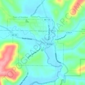
Name: Topografische Karte Ontario, Höhe, Relief.
Ort: Ontario, Vernon County, Wisconsin, United States (43.71463 -90.60706 43.72961 -90.58236)
Durchschnittliche Höhe: 294 m
Minimale Höhe: 260 m
Maximale Höhe: 395 m
Andere topografische Karten
Klicken Sie auf eine Karte, um ihre Topografie, ihre Höhe und ihr Relief anzuzeigen.
Genoa
United States > Wisconsin > Vernon County
Genoa, Vernon County, Wisconsin, United States
Durchschnittliche Höhe: 240 m
Town of Jefferson
United States > Wisconsin > Vernon County
Town of Jefferson, Vernon County, Wisconsin, United States
Durchschnittliche Höhe: 351 m
Coon Valley
United States > Wisconsin > Vernon County
Coon Valley, Vernon County, Wisconsin, United States
Durchschnittliche Höhe: 271 m
DeSoto Bay
United States > Wisconsin > Vernon County > De Soto
DeSoto Bay, De Soto, Town of Wheatland, Vernon County, Wisconsin, United States
Durchschnittliche Höhe: 224 m
Hillsboro
United States > Wisconsin > Vernon County
Hillsboro, Vernon County, Wisconsin, United States
Durchschnittliche Höhe: 307 m
Town of Whitestown
United States > Wisconsin > Vernon County
Town of Whitestown, Vernon County, Wisconsin, United States
Durchschnittliche Höhe: 321 m
Viroqua
United States > Wisconsin > Vernon County
Viroqua, Vernon County, Wisconsin, 54665, United States
Durchschnittliche Höhe: 376 m
Rockton
United States > Wisconsin > Vernon County > Rockton
Rockton, Town of Whitestown, Vernon County, Wisconsin, United States
Durchschnittliche Höhe: 292 m
De Soto
United States > Wisconsin > Vernon County
De Soto, Vernon County, Wisconsin, United States
Durchschnittliche Höhe: 245 m