
Spenden
Rüste dich für dein nächstes Abenteuer:
Als Amazon-Partner verdient diese Website an qualifizierten Käufen, ohne zusätzliche Kosten für Sie.
Topografische Karte Magothy River
Klicken Sie auf die Karte, um die Höhe anzuzeigen.
Spenden
Rüste dich für dein nächstes Abenteuer:
Als Amazon-Partner verdient diese Website an qualifizierten Käufen, ohne zusätzliche Kosten für Sie.
Magothy River
Almost all of the creeks and tidal coves on the Magothy are named, partly as the result of a project started in 2001 by the Magothy River Association. They are shown on a map produced as part of that project, and the major ones are shown on the USGS topographic map.
Spenden
Rüste dich für dein nächstes Abenteuer:
Als Amazon-Partner verdient diese Website an qualifizierten Käufen, ohne zusätzliche Kosten für Sie.
Über diese Karte
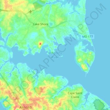
Name: Topografische Karte Magothy River, Höhe, Relief.
Durchschnittliche Höhe: 9 m
Minimale Höhe: -3 m
Maximale Höhe: 46 m
Spenden
Rüste dich für dein nächstes Abenteuer:
Als Amazon-Partner verdient diese Website an qualifizierten Käufen, ohne zusätzliche Kosten für Sie.
Andere topografische Karten
Klicken Sie auf eine Karte, um ihre Topografie, ihre Höhe und ihr Relief anzuzeigen.
Magothy Forest
United States > Maryland > Anne Arundel County > Severna Park
Durchschnittliche Höhe: 13 m
Longmeadow North
United States > Maryland > Anne Arundel County > Severna Park
Durchschnittliche Höhe: 8 m
Lower Magothy Beach
United States > Maryland > Anne Arundel County > Severna Park > Lower Magothy Beach
Durchschnittliche Höhe: 9 m
Windrush Farm
United States > Maryland > Anne Arundel County > Severna Park > Windrush Farm
Durchschnittliche Höhe: 10 m
Spenden
Rüste dich für dein nächstes Abenteuer:
Als Amazon-Partner verdient diese Website an qualifizierten Käufen, ohne zusätzliche Kosten für Sie.
Severndale
United States > Maryland > Anne Arundel County > Severna Park > Severndale
Durchschnittliche Höhe: 18 m
Linstead-on-the-Severn
United States > Maryland > Anne Arundel County > Severna Park
Durchschnittliche Höhe: 11 m