
Topografische Karte Korbel
Interaktive Karte
Klicken Sie auf die Karte, um die Höhe anzuzeigen.
Über diese Karte
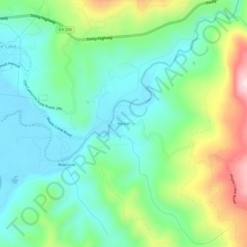
Name: Topografische Karte Korbel, Höhe, Relief.
Ort: Korbel, Humboldt County, California, 95525, United States (40.85041 -123.97839 40.89041 -123.93839)
Durchschnittliche Höhe: 150 m
Minimale Höhe: 24 m
Maximale Höhe: 451 m
Andere topografische Karten
Klicken Sie auf eine Karte, um ihre Topografie, ihre Höhe und ihr Relief anzuzeigen.
Capetown
United States > California > Humboldt County
Capetown, Humboldt County, California, United States
Durchschnittliche Höhe: 163 m
Cape Mendocino
United States > California > Humboldt County
Cape Mendocino, Humboldt County, California, United States
Durchschnittliche Höhe: 59 m
Mount Baldy
United States > California > Humboldt County
Mount Baldy, Humboldt County, California, United States
Durchschnittliche Höhe: 613 m
Moonstone
United States > California > Humboldt County > Moonstone
Moonstone, Humboldt County, California, United States
Durchschnittliche Höhe: 60 m
Fortuna
United States > California > Humboldt County > Fortuna
Fortuna, Humboldt County, California, 95540, United States
Durchschnittliche Höhe: 64 m
Eureka
United States > California > Humboldt County > Eureka
Eureka, Humboldt County, California, 95502, United States
Durchschnittliche Höhe: 100 m
Eureka
United States > California > Humboldt County
Eureka, Humboldt County, California, United States
Durchschnittliche Höhe: 18 m
Garberville
United States > California > Humboldt County
Garberville, Humboldt County, California, 95542, United States
Durchschnittliche Höhe: 198 m
Myers Flat
United States > California > Humboldt County
Myers Flat, Humboldt County, California, 95554, United States
Durchschnittliche Höhe: 223 m