
Topografische Karte Jammu
Klicken Sie auf die Karte, um die Höhe anzuzeigen.
Jammu
Jammu is located at 32°44′N 74°52′E / 32.73°N 74.87°E / 32.73; 74.87. It has an average elevation of 300 m (980 ft). Jammu city lies at uneven ridges of low heights at the Shivalik hills. It is surrounded by the Shivalik range to the north, east, and southeast while the Trikuta Range surrounds it in the northwest. It is approximately 600 kilometres (370 mi) from the national capital, New Delhi.
Über diese Karte
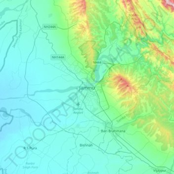
Name: Topografische Karte Jammu, Höhe, Relief.
Ort: Jammu, Jammu district, Jammu and Kashmir, 180001, India (32.55856 74.69809 32.87856 75.01809)
Durchschnittliche Höhe: 367 m
Minimale Höhe: 255 m
Maximale Höhe: 987 m
Andere topografische Karten
Klicken Sie auf eine Karte, um ihre Topografie, ihre Höhe und ihr Relief anzuzeigen.
Municipal Park Paloura (Palourka)
India > Jammu and Kashmir > Jammu > Jammu
Durchschnittliche Höhe: 354 m