
Spenden
Rüste dich für dein nächstes Abenteuer:
Als Amazon-Partner verdient diese Website an qualifizierten Käufen, ohne zusätzliche Kosten für Sie.
Topografische Karte Eureka
Klicken Sie auf die Karte, um die Höhe anzuzeigen.
Spenden
Rüste dich für dein nächstes Abenteuer:
Als Amazon-Partner verdient diese Website an qualifizierten Käufen, ohne zusätzliche Kosten für Sie.
Eureka
The city marina is on one of three islands at a narrow point on the 13-mile-long (21 km) bay and increases in elevation slightly as it spreads north, south, and especially to the east. The city gently encroaches at least two miles (3.2 km) eastward into primarily Redwood and Douglas-fir second growth forests. The city has a traditional grid that generally radiates toward the points of the compass. Most post-1970 houses were built in formerly clear cut forested areas.
Spenden
Rüste dich für dein nächstes Abenteuer:
Als Amazon-Partner verdient diese Website an qualifizierten Käufen, ohne zusätzliche Kosten für Sie.
Über diese Karte
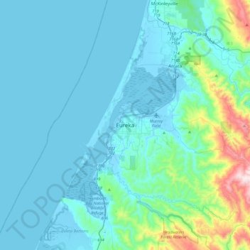
Name: Topografische Karte Eureka, Höhe, Relief.
Ort: Eureka, Humboldt County, California, 95502, United States (40.63069 -124.32737 40.95069 -124.00737)
Durchschnittliche Höhe: 100 m
Minimale Höhe: -5 m
Maximale Höhe: 854 m
Spenden
Rüste dich für dein nächstes Abenteuer:
Als Amazon-Partner verdient diese Website an qualifizierten Käufen, ohne zusätzliche Kosten für Sie.