
Topografische Karte Cassadaga
Interaktive Karte
Klicken Sie auf die Karte, um die Höhe anzuzeigen.
Über diese Karte
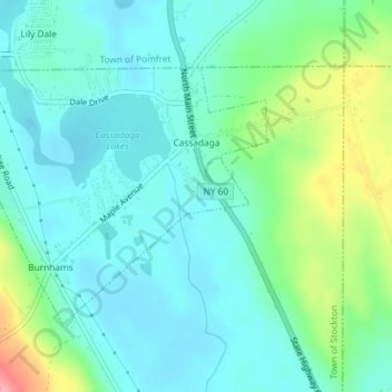
Name: Topografische Karte Cassadaga, Höhe, Relief.
Ort: Cassadaga, Chautauqua County, New York, United States (42.33188 -79.33090 42.34936 -79.30251)
Durchschnittliche Höhe: 418 m
Minimale Höhe: 391 m
Maximale Höhe: 499 m
Cassadaga is located on the northwestern edge of the Allegheny Plateau in western New York at 42°20'29" north, 79°18'56" west (42.341343, -79.315653) at an elevation of approximately 1,340 feet (410 m) above sea level. The village is located at the south end of Lower Cassadaga Lake, Lily Dale being located on the east shore of Upper Cassadaga Lake, with a narrow "Middle Lake" connecting them. The mainly spring-fed lakes drain into Cassadaga Creek, running south and connecting to Conewango Creek, the Allegheny River, the Ohio River, and the Mississippi River flowing to the Gulf of Mexico, despite getting their start just 10 miles (16 km) south and east of Lake Erie, one of the Great Lakes, which drain via the Saint Lawrence River east to the Atlantic Ocean. The watershed divide is located less than 2 miles (3 km) north of the village.