
Spenden
Rüste dich für dein nächstes Abenteuer:
Als Amazon-Partner verdient diese Website an qualifizierten Käufen, ohne zusätzliche Kosten für Sie.
Topografische Karte Acton
Klicken Sie auf die Karte, um die Höhe anzuzeigen.
Spenden
Rüste dich für dein nächstes Abenteuer:
Als Amazon-Partner verdient diese Website an qualifizierten Käufen, ohne zusätzliche Kosten für Sie.
Über diese Karte
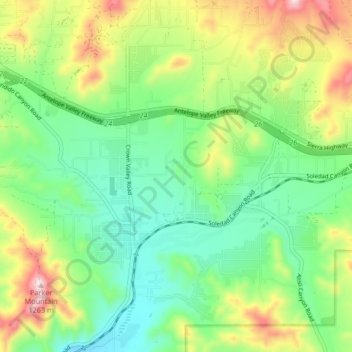
Name: Topografische Karte Acton, Höhe, Relief.
Durchschnittliche Höhe: 947 m
Minimale Höhe: 785 m
Maximale Höhe: 1.253 m
Spenden
Rüste dich für dein nächstes Abenteuer:
Als Amazon-Partner verdient diese Website an qualifizierten Käufen, ohne zusätzliche Kosten für Sie.
Andere topografische Karten
Klicken Sie auf eine Karte, um ihre Topografie, ihre Höhe und ihr Relief anzuzeigen.
Los Angeles
United States > California > Los Angeles County
Los Angeles is characterized by a diverse and dynamic topography. The city is predominantly situated in a basin bordered by mountain ranges, including the Santa Monica Mountains to the north and the San Gabriel Mountains to the east, with elevations reaching up to about 10,000 feet (3,048 meters) in certain…
Durchschnittliche Höhe: 241 m
Pasadena
United States > California > Los Angeles County
An obscure portion of the Angeles Crest Highway (SR 2) in the San Gabriel Mountains cuts through Pasadena near the Angeles Crest Ranger Station. This 2-mile (3.2 km) stretch of highway in the Angeles National Forest is north of La Cañada Flintridge and west of Mount Wilson and is approximately 3,000 feet (910…
Durchschnittliche Höhe: 548 m
Santa Catalina Island
United States > California > Los Angeles County > Avalon
Catalina is primarily composed of two distinct rock units: Catalina Schist from the Early Cretaceous (95 to 109 million years ago), and Miocene volcanic and intrusive igneous rocks. The island is rich in quartz, to the extent that some beaches on the seaward side have silvery-grey sand. These formations…
Durchschnittliche Höhe: 60 m
Spenden
Rüste dich für dein nächstes Abenteuer:
Als Amazon-Partner verdient diese Website an qualifizierten Käufen, ohne zusätzliche Kosten für Sie.
Santa Clarita
United States > California > Los Angeles County
The official elevation of the city is 1,207 feet (368 m), the elevation of the historic Newhall Airport which was northwest of Via Princessa and Railroad Avenue from the 1930s through the 1950s. Elevation varies substantially throughout the city. The lowest point in Santa Clarita is near the junction of CA-126…
Durchschnittliche Höhe: 514 m
Spenden
Rüste dich für dein nächstes Abenteuer:
Als Amazon-Partner verdient diese Website an qualifizierten Käufen, ohne zusätzliche Kosten für Sie.
Griffith Park
United States > California > Los Angeles County > Los Angeles
Durchschnittliche Höhe: 221 m
La Cañada Flintridge
United States > California > Los Angeles County
La Cañada Flintridge varies in elevation from about 970 feet (300 m) just below Devil's Gate Dam in the Arroyo Seco to about 2,400 feet (730 m) at the highest neighborhood, along the mountain front east of Pickens Canyon, at the upper end of Ocean View Blvd. The city limits extend into the San Gabriel…
Durchschnittliche Höhe: 503 m
Van Nuys Neighborhood Council District
United States > California > Los Angeles County > Los Angeles
Durchschnittliche Höhe: 224 m
Spenden
Rüste dich für dein nächstes Abenteuer:
Als Amazon-Partner verdient diese Website an qualifizierten Käufen, ohne zusätzliche Kosten für Sie.
Long Beach
United States > California > Los Angeles County
Willow Springs Park was founded as a part of the Willow Springs Wetlands Restoration Project which opened in October 2017. The project restored 11 acres of a 48-acre degraded oil well site into wetlands. These highlight the pivotal role the ecosystem played in the City of Long Beach’s establishment in the…
Durchschnittliche Höhe: 12 m
Angeles National Forest
United States > California > Los Angeles County
The Angeles National Forest manages the habitats, flora and fauna ecosystems, and watersheds. Some of the rivers with watersheds within its boundaries provide valuable non-groundwater recharge water for Southern California. The existing protected and restored native vegetation absorb and slow surface runoff of…
Durchschnittliche Höhe: 782 m
San Fernando Valley
United States > California > Los Angeles County > Los Angeles
Durchschnittliche Höhe: 496 m
Spenden
Rüste dich für dein nächstes Abenteuer:
Als Amazon-Partner verdient diese Website an qualifizierten Käufen, ohne zusätzliche Kosten für Sie.
San Clemente Island
United States > California > Los Angeles County
Its highest point is Mount Thirst, at 1,965 feet (599 m) in elevation. The elevation of the island's ridge can impact precipitation, as it can cause atmospheric moisture to condense and cause more intense precipitation. This was a factor in the intense rainstorm that hit San Diego on January 22, 2024.
Durchschnittliche Höhe: 49 m
Whittier
United States > California > Los Angeles County
Whittier is about 15 miles (24 km) inland of the Pacific Ocean, resulting in higher daytime temperatures, and since it lies at a higher elevation than the cities further west, cold air drains into the lower elevation of the Los Angeles Basin which results in warmer night-time lows, producing an example of…
Durchschnittliche Höhe: 115 m
Palos Verdes
United States > California > Los Angeles County > Rancho Palos Verdes
Durchschnittliche Höhe: 49 m
Spenden
Rüste dich für dein nächstes Abenteuer:
Als Amazon-Partner verdient diese Website an qualifizierten Käufen, ohne zusätzliche Kosten für Sie.
Lancaster
United States > California > Los Angeles County
According to the United States Census Bureau, the city has a total area of 94.5 square miles (245 km2), of which 94.3 square miles (244 km2) is land and 0.3 square miles (0.78 km2) (0.29%) is water. Lancaster's elevation is 2,350 feet (720 m) above sea level on a high, flat valley surrounded by pristine…
Durchschnittliche Höhe: 787 m
Sierra Madre
United States > California > Los Angeles County
In 1908, the first Mt. Wilson Trail Race was run. This annual race was discontinued during WWII and reestablished in 1966. The 102nd anniversary of the first running of the Mount Wilson Trail Race and the 44th annual race was run in May 2010. Because of rain, mudslides, falling trees, soil erosion and…
Durchschnittliche Höhe: 361 m
Venice Beach
United States > California > Los Angeles County > Los Angeles
Durchschnittliche Höhe: 4 m
Spenden
Rüste dich für dein nächstes Abenteuer:
Als Amazon-Partner verdient diese Website an qualifizierten Käufen, ohne zusätzliche Kosten für Sie.
Encino Neighborhood Council District
United States > California > Los Angeles County > Los Angeles
Durchschnittliche Höhe: 288 m
Long Beach
United States > California > Los Angeles County
Willow Springs Park was founded as a part of the Willow Springs Wetlands Restoration Project which opened in October 2017. The project restored 11 acres of a 48-acre degraded oil well site into wetlands. These highlight the pivotal role the ecosystem played in the City of Long Beach’s establishment in the…
Durchschnittliche Höhe: 12 m
Spenden
Rüste dich für dein nächstes Abenteuer:
Als Amazon-Partner verdient diese Website an qualifizierten Käufen, ohne zusätzliche Kosten für Sie.
Spenden
Rüste dich für dein nächstes Abenteuer:
Als Amazon-Partner verdient diese Website an qualifizierten Käufen, ohne zusätzliche Kosten für Sie.
Burbank
United States > California > Los Angeles County
Elevations in the city range from 500 feet (150 m) in the lower valley areas to about 800 feet (240 m) near the Verdugo Mountains. Most of Burbank features a water table more than 100 feet (30 m) deep, more than the measures found in the 1940s when the water table was within 50 feet (15 m) of the ground…
Durchschnittliche Höhe: 290 m
Spenden
Rüste dich für dein nächstes Abenteuer:
Als Amazon-Partner verdient diese Website an qualifizierten Käufen, ohne zusätzliche Kosten für Sie.
Malibu
United States > California > Los Angeles County
The Malibu Coast lies on the fringe of an extensive chaparral and woodland wilderness area, the Santa Monica Mountains National Recreation Area. Various environmental elements collectively create a recipe for natural disasters: the mountainous and geologically unstable terrain; seasonal rainstorms that result…
Durchschnittliche Höhe: 144 m
Spenden
Rüste dich für dein nächstes Abenteuer:
Als Amazon-Partner verdient diese Website an qualifizierten Käufen, ohne zusätzliche Kosten für Sie.
Harbor Pines
United States > California > Los Angeles County > Los Angeles
Durchschnittliche Höhe: 45 m
Spenden
Rüste dich für dein nächstes Abenteuer:
Als Amazon-Partner verdient diese Website an qualifizierten Käufen, ohne zusätzliche Kosten für Sie.
Spenden
Rüste dich für dein nächstes Abenteuer:
Als Amazon-Partner verdient diese Website an qualifizierten Käufen, ohne zusätzliche Kosten für Sie.
San Gabriel Mountains National Monument
United States > California > Los Angeles County
Durchschnittliche Höhe: 817 m
Spenden
Rüste dich für dein nächstes Abenteuer:
Als Amazon-Partner verdient diese Website an qualifizierten Käufen, ohne zusätzliche Kosten für Sie.
Spenden
Rüste dich für dein nächstes Abenteuer:
Als Amazon-Partner verdient diese Website an qualifizierten Käufen, ohne zusätzliche Kosten für Sie.
Unincorporated Santa Monica Mountains
United States > California > Los Angeles County
Durchschnittliche Höhe: 215 m
Spenden
Rüste dich für dein nächstes Abenteuer:
Als Amazon-Partner verdient diese Website an qualifizierten Käufen, ohne zusätzliche Kosten für Sie.
Mount San Antonio
United States > California > Los Angeles County
The prehistoric Hog Back landslide lies in the canyon of San Antonio Creek at 4000' elevation. When the slide occurred, it dammed the river, whose depth built up until the water was released catastrophically, forming a slot canyon which now holds some of the area's few good rock climbing routes (difficulty…
Durchschnittliche Höhe: 2.675 m
Spenden
Rüste dich für dein nächstes Abenteuer:
Als Amazon-Partner verdient diese Website an qualifizierten Käufen, ohne zusätzliche Kosten für Sie.
Valley Village Neighborhood Council District
United States > California > Los Angeles County > Los Angeles
Durchschnittliche Höhe: 199 m
Hungry Valley SVRA
United States > California > Los Angeles County > Gorman
Durchschnittliche Höhe: 1.303 m
Spenden
Rüste dich für dein nächstes Abenteuer:
Als Amazon-Partner verdient diese Website an qualifizierten Käufen, ohne zusätzliche Kosten für Sie.
Studio City Neighborhood Council District
United States > California > Los Angeles County > Los Angeles
Durchschnittliche Höhe: 255 m
Unincorporated Chatsworth
United States > California > Los Angeles County
Durchschnittliche Höhe: 563 m
Canoga Park Neighborhood Council District
United States > California > Los Angeles County > Los Angeles
Durchschnittliche Höhe: 255 m
Spenden
Rüste dich für dein nächstes Abenteuer:
Als Amazon-Partner verdient diese Website an qualifizierten Käufen, ohne zusätzliche Kosten für Sie.
Universal City Overlook
United States > California > Los Angeles County > Los Angeles
Durchschnittliche Höhe: 278 m
Green Valley
United States > California > Los Angeles County
Green Valley is an unincorporated community and census-designated place (CDP) in the Sierra Pelona Mountains, in Los Angeles County, California. It lies at an elevation of 2936 feet (895 m). The population was 1,036 at the 2020 census, up from 1,027 at the 2010 census.
Durchschnittliche Höhe: 1.067 m
Spenden
Rüste dich für dein nächstes Abenteuer:
Als Amazon-Partner verdient diese Website an qualifizierten Käufen, ohne zusätzliche Kosten für Sie.
Green Valley
United States > California > Los Angeles County
Green Valley is an unincorporated community and census-designated place (CDP) in the Sierra Pelona Mountains, in Los Angeles County, California. It lies at an elevation of 2936 feet (895 m). The population was 1,036 at the 2020 census, up from 1,027 at the 2010 census.
Durchschnittliche Höhe: 1.057 m
Porter Ranch Neighborhood Council District
United States > California > Los Angeles County > Los Angeles
Durchschnittliche Höhe: 460 m
Spenden
Rüste dich für dein nächstes Abenteuer:
Als Amazon-Partner verdient diese Website an qualifizierten Käufen, ohne zusätzliche Kosten für Sie.
Mount Baden-Powell
United States > California > Los Angeles County
At 9,407 feet (2,867 m) in elevation, Mount Baden-Powell is traditionally considered to be the 5th highest peak of the San Gabriel Range; however it is the second highest peak in the range with more than 1,000 feet (300 m) of prominence, and is the highest peak not part of the Mount San Antonio massif.
Durchschnittliche Höhe: 2.429 m
San Clemente Island
United States > California > Los Angeles County
Its highest point is Mount Thirst, at 1965 feet in elevation. The elevation of the island's ridge can impact precipitation, as it can cause atmospheric moisture to condense and cause more intense precipitation. This was a factor in the intense rainstorm that hit San Diego on January 22, 2024.
Durchschnittliche Höhe: 49 m
Spenden
Rüste dich für dein nächstes Abenteuer:
Als Amazon-Partner verdient diese Website an qualifizierten Käufen, ohne zusätzliche Kosten für Sie.
Spenden
Rüste dich für dein nächstes Abenteuer:
Als Amazon-Partner verdient diese Website an qualifizierten Käufen, ohne zusätzliche Kosten für Sie.
Lake Los Angeles
United States > California > Los Angeles County > Lake Los Angeles
Durchschnittliche Höhe: 828 m
Spenden
Rüste dich für dein nächstes Abenteuer:
Als Amazon-Partner verdient diese Website an qualifizierten Käufen, ohne zusätzliche Kosten für Sie.
Agoura Hills
United States > California > Los Angeles County
Agoura Hills has a mountain called Ballard Mountain named after pioneer settler and freed slave John Ballard. The name of the mountain was officially changed from Negrohead to Ballard in a ceremony on February 20, 2010. Ladyface Mountain is another prominent mountain on the west side of the Conejo Valley and…
Durchschnittliche Höhe: 332 m
Spenden
Rüste dich für dein nächstes Abenteuer:
Als Amazon-Partner verdient diese Website an qualifizierten Käufen, ohne zusätzliche Kosten für Sie.