
Topografische Karte Madison
Interaktive Karte
Klicken Sie auf die Karte, um die Höhe anzuzeigen.
Über diese Karte
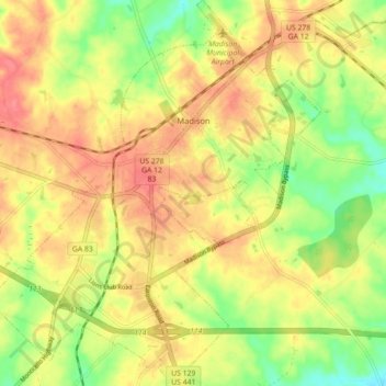
Name: Topografische Karte Madison, Höhe, Relief.
Ort: Madison, Morgan County, Georgia, United States (33.54487 -83.51538 33.61875 -83.43872)
Durchschnittliche Höhe: 195 m
Minimale Höhe: 156 m
Maximale Höhe: 225 m
Madison is located at 33°35′17″N 83°28′21″W / 33.58806°N 83.47250°W / 33.58806; -83.47250 (33.588038, -83.472368). According to the United States Census Bureau, the city has a total area of 8.9 square miles (23 km2), of which, 8.9 square miles (23 km2) of it is land and 0.04 square miles (0.10 km2) of it (0.45%) is water. Madison is situated on a high ridge which traverses Morgan County from the northeast to the southwest at an elevation of 760 feet.
Andere topografische Karten
Klicken Sie auf eine Karte, um ihre Topografie, ihre Höhe und ihr Relief anzuzeigen.
Bostwick
United States > Georgia > Morgan County
Bostwick, Morgan County, Georgia, United States
Durchschnittliche Höhe: 221 m
Rutledge
United States > Georgia > Morgan County
Rutledge, Morgan County, Georgia, United States
Durchschnittliche Höhe: 211 m
Fairplay
United States > Georgia > Morgan County
Fairplay, Morgan County, Georgia, United States
Durchschnittliche Höhe: 223 m