
Topografische Karte Hidden Falls
Interaktive Karte
Klicken Sie auf die Karte, um die Höhe anzuzeigen.
Über diese Karte
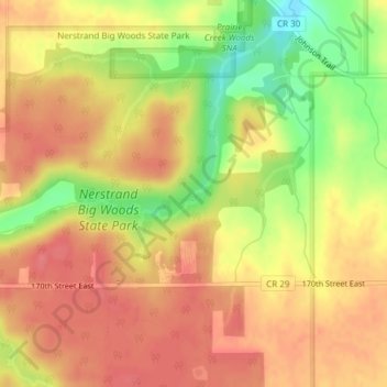
Name: Topografische Karte Hidden Falls, Höhe, Relief.
Ort: Hidden Falls, Rice County, Minnesota, 55053, United States (44.34796 -93.10287 44.34806 -93.10277)
Durchschnittliche Höhe: 353 m
Minimale Höhe: 307 m
Maximale Höhe: 377 m
Andere topografische Karten
Klicken Sie auf eine Karte, um ihre Topografie, ihre Höhe und ihr Relief anzuzeigen.
Faribault
United States > Minnesota > Rice County
Faribault, Rice County, Minnesota, 55021, United States
Durchschnittliche Höhe: 325 m
Northfield
United States > Minnesota > Rice County
Northfield, Rice County, Minnesota, 55057, United States
Durchschnittliche Höhe: 300 m
Nerstrand Big Woods State Park
United States > Minnesota > Rice County
Nerstrand Big Woods State Park, Rice County, Minnesota, United States
Durchschnittliche Höhe: 356 m
Morristown
United States > Minnesota > Rice County
Morristown, Rice County, Minnesota, United States
Durchschnittliche Höhe: 316 m
Hazelwood
United States > Minnesota > Rice County
Hazelwood, Rice County, Minnesota, United States
Durchschnittliche Höhe: 316 m
Warsaw
United States > Minnesota > Rice County
Warsaw, Rice County, Minnesota, 55087, United States
Durchschnittliche Höhe: 315 m
Shieldsville
United States > Minnesota > Rice County
Shieldsville, Rice County, Minnesota, United States
Durchschnittliche Höhe: 333 m
Walcott
United States > Minnesota > Rice County
Walcott, Rice County, Minnesota, United States
Durchschnittliche Höhe: 361 m
Veseli
United States > Minnesota > Rice County
Veseli, Rice County, Minnesota, United States
Durchschnittliche Höhe: 327 m
Cannon City
United States > Minnesota > Rice County
Cannon City, Rice County, Minnesota, United States
Durchschnittliche Höhe: 348 m
Lonsdale
United States > Minnesota > Rice County
Lonsdale, Rice County, Minnesota, 55046, United States
Durchschnittliche Höhe: 336 m
Northfield
United States > Minnesota > Rice County
Northfield, Dundas, Rice County, Minnesota, 55057, United States
Durchschnittliche Höhe: 300 m