
Topografische Karte Page
Klicken Sie auf die Karte, um die Höhe anzuzeigen.
Page
Unlike other cities in the area, Page was founded in 1957 as a housing community for workers and their families during the construction of nearby Glen Canyon Dam on the Colorado River. Its 17-square-mile (44 km2) site was obtained in a land exchange with the Navajo Nation. The city is perched atop Manson Mesa at an elevation of 4,300 feet (1,300 m) above sea level and 600 feet (180 m) above Lake Powell.
Über diese Karte
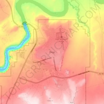
Name: Topografische Karte Page, Höhe, Relief.
Ort: Page, Coconino County, Arizona, 86040-0418, United States (36.87483 -111.49729 36.95483 -111.41729)
Durchschnittliche Höhe: 1.242 m
Minimale Höhe: 949 m
Maximale Höhe: 1.403 m