
Topografische Karte Sequoia National Park
Interaktive Karte
Klicken Sie auf die Karte, um die Höhe anzuzeigen.
Über diese Karte
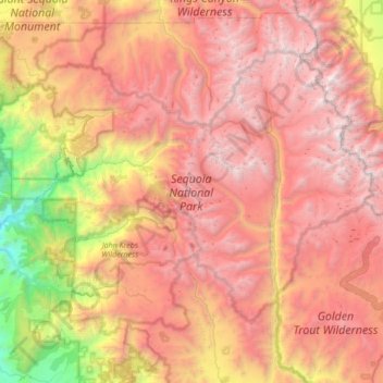
Name: Topografische Karte Sequoia National Park, Höhe, Relief.
Durchschnittliche Höhe: 2.515 m
Minimale Höhe: 265 m
Maximale Höhe: 4.401 m
Many park visitors enter Sequoia National Park through its southern entrance near the town of Three Rivers at Ash Mountain at 1,700 ft (520 m) elevation. The lower elevations around Ash Mountain contain the only National Park Service-protected California Foothills ecosystem, consisting of blue oak woodlands, foothills chaparral, grasslands, yucca plants, and steep, mild river valleys. Seasonal weather results in a changing landscape throughout the foothills with hot summer yielding an arid landscape while spring and winter rains result in blossoming wildflowers and lush greens. The region is also home to abundant wildlife: bobcats, foxes, ground squirrels, rattlesnakes, and mule deer are commonly seen in this area, and more rarely, reclusive mountain lions and the Pacific fisher are seen as well. The last California grizzly was killed in this park in 1922 (at Horse Corral Meadow). The California Black Oak is a key transition species between the chaparral and higher elevation conifer forest.
Andere topografische Karten
Klicken Sie auf eine Karte, um ihre Topografie, ihre Höhe und ihr Relief anzuzeigen.
Visalia
United States > California > Tulare County
Visalia, Tulare County, California, United States
Durchschnittliche Höhe: 102 m
Three Rivers
United States > California > Tulare County
Three Rivers, Tulare County, California, United States
Durchschnittliche Höhe: 762 m
Mineral King
United States > California > Tulare County
Mineral King, Tulare County, California, United States
Durchschnittliche Höhe: 2.783 m
Curtis Mountain
United States > California > Tulare County
Curtis Mountain, Tulare County, California, United States
Durchschnittliche Höhe: 188 m
Redwood Mountain
United States > California > Tulare County
Redwood Mountain, Tulare County, California, United States
Durchschnittliche Höhe: 1.826 m
Springville
United States > California > Tulare County
Springville, Tulare County, California, 93265, United States
Durchschnittliche Höhe: 374 m
Grant Grove Village
United States > California > Tulare County
Grant Grove Village, Tulare County, California, 93633, United States
Durchschnittliche Höhe: 2.015 m
Lindsay
United States > California > Tulare County
Lindsay, Tulare County, California, 93247, United States
Durchschnittliche Höhe: 118 m
Ponderosa
United States > California > Tulare County
Ponderosa, Tulare County, California, United States
Durchschnittliche Höhe: 2.222 m
Lindsay
United States > California > Tulare County > Lindsay > Lindsay
Lindsay, Tulare County, California, 93247, United States
Durchschnittliche Höhe: 131 m
Sierra Nevada
United States > California > Tulare County
Sierra Nevada, Tulare County, California, United States
Durchschnittliche Höhe: 3.888 m