
Spenden
Rüste dich für dein nächstes Abenteuer:
Als Amazon-Partner verdient diese Website an qualifizierten Käufen, ohne zusätzliche Kosten für Sie.
Topografische Karte Madau
Klicken Sie auf die Karte, um die Höhe anzuzeigen.
Spenden
Rüste dich für dein nächstes Abenteuer:
Als Amazon-Partner verdient diese Website an qualifizierten Käufen, ohne zusätzliche Kosten für Sie.
Über diese Karte
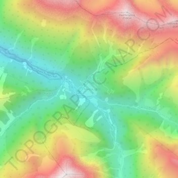
Name: Topografische Karte Madau, Höhe, Relief.
Ort: Madau, Zams, Bezirk Landeck, Tyrol, 6511, Austria (47.21354 10.43246 47.25354 10.47246)
Durchschnittliche Höhe: 1.780 m
Minimale Höhe: 1.169 m
Maximale Höhe: 2.589 m
Spenden
Rüste dich für dein nächstes Abenteuer:
Als Amazon-Partner verdient diese Website an qualifizierten Käufen, ohne zusätzliche Kosten für Sie.
Andere topografische Karten
Klicken Sie auf eine Karte, um ihre Topografie, ihre Höhe und ihr Relief anzuzeigen.
Ischgl
Austria > Tyrol > Bezirk Landeck
Ischgl has a weather station at an altitude of 2,327 m (7,635 ft). This weather station is located within the alpine climate zone (Köppen ETH), closely bordering on a subarctic climate (Köppen Dfc), because the hottest month is only 9.9 °C (49.8 °F).
Durchschnittliche Höhe: 2.251 m
Spenden
Rüste dich für dein nächstes Abenteuer:
Als Amazon-Partner verdient diese Website an qualifizierten Käufen, ohne zusätzliche Kosten für Sie.
Spenden
Rüste dich für dein nächstes Abenteuer:
Als Amazon-Partner verdient diese Website an qualifizierten Käufen, ohne zusätzliche Kosten für Sie.
Nauders
Austria > Tyrol > Bezirk Landeck
The town lies in the valley of the Stillebach (a tributary of the Inn) in the Ötztal Alps, at an altitude of 1,394 m (4,573 ft). It is located about 29 km (18 mi) south of the district capital Landeck, on the road that leads from Pfunds in the Inntal valley via the narrow Finstermünz Gorge up to Reschen Pass…
Durchschnittliche Höhe: 1.938 m
Ischgl
Austria > Tyrol > Bezirk Landeck
Ischgl has a weather station at an altitude of 2,327 m (7,635 ft). This weather station is located within the alpine climate zone (Köppen ETH), closely bordering on a subarctic climate (Köppen Dfc), because the hottest month is only 9.9 °C (49.8 °F).
Durchschnittliche Höhe: 2.251 m
Spenden
Rüste dich für dein nächstes Abenteuer:
Als Amazon-Partner verdient diese Website an qualifizierten Käufen, ohne zusätzliche Kosten für Sie.
Kaunertal
Austria > Tyrol > Bezirk Landeck
The Kaunertal valley is 28 km (17 mi) in length and runs southeast from the town of Prutz (884 m) to the Kaunertal Glacier. The valley is traversed by the Faggenbach river, which rises south of the Weißseespitze mountain (3044 m) and flows into the Inn river at Prutz (884 m), the site of a hydroelectric power…
Durchschnittliche Höhe: 2.399 m
Spenden
Rüste dich für dein nächstes Abenteuer:
Als Amazon-Partner verdient diese Website an qualifizierten Käufen, ohne zusätzliche Kosten für Sie.
Nauders
Austria > Tyrol > Bezirk Landeck
The town lies in the valley of the Stillebach (a tributary of the Inn) in the Ötztal Alps, at an altitude of 1,394 m (4,573 ft). It is located about 29 km (18 mi) south of the district capital Landeck, on the road that leads from Pfunds in the Inntal valley via the narrow Finstermünz Gorge up to Reschen Pass…
Durchschnittliche Höhe: 1.938 m
Ischgl
Austria > Tyrol > Bezirk Landeck
Ischgl has a weather station at an altitude of 2,327 m (7,635 ft). This weather station is located within the alpine climate zone (Köppen ETH), closely bordering on a subarctic climate (Köppen Dfc), because the hottest month is only 9.9 °C (49.8 °F).
Durchschnittliche Höhe: 2.251 m
Spenden
Rüste dich für dein nächstes Abenteuer:
Als Amazon-Partner verdient diese Website an qualifizierten Käufen, ohne zusätzliche Kosten für Sie.