
Topografische Karte Lipa
Interaktive Karte
Klicken Sie auf die Karte, um die Höhe anzuzeigen.
Über diese Karte
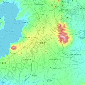
Name: Topografische Karte Lipa, Höhe, Relief.
Ort: Lipa, Batangas, Calabarzon, 4217, Philippines (13.78147 121.00429 14.10147 121.32429)
Durchschnittliche Höhe: 163 m
Minimale Höhe: -4 m
Maximale Höhe: 955 m
At the celebration of the elevation of Lipa to a city in January 1888, José Rizal was invited by Dr. Jose Lozada, Catalino Dimayuga and the brothers Celestino and Simeon Luz but Rizal responded only with his Hymno Al Trabajo which he dedicated to the zeal and industry of the Lipeños.
Andere topografische Karten
Klicken Sie auf eine Karte, um ihre Topografie, ihre Höhe und ihr Relief anzuzeigen.
Amiya Rosa Phase 1
Philippines > Batangas > Lipa
Amiya Rosa Phase 1, Lipa, Batangas, Calabarzon, 7750, Philippines
Durchschnittliche Höhe: 310 m
Bulacnin
Philippines > Batangas > Lipa > Bulacnin
Bulacnin, Lipa, Batangas, Calabarzon, 4223, Philippines
Durchschnittliche Höhe: 321 m
7
Philippines > Batangas > Lipa
7, Lipa, Batangas, Calabarzon, 4217, Philippines
Durchschnittliche Höhe: 312 m