
Spenden
Rüste dich für dein nächstes Abenteuer:
Als Amazon-Partner verdient diese Website an qualifizierten Käufen, ohne zusätzliche Kosten für Sie.
Topografische Karte Ashford
Klicken Sie auf die Karte, um die Höhe anzuzeigen.
Spenden
Rüste dich für dein nächstes Abenteuer:
Als Amazon-Partner verdient diese Website an qualifizierten Käufen, ohne zusätzliche Kosten für Sie.
Über diese Karte
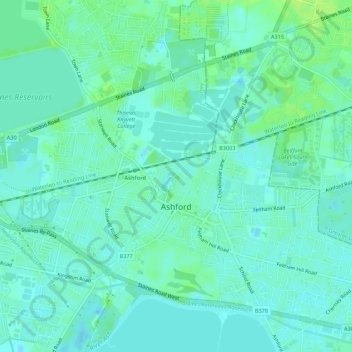
Name: Topografische Karte Ashford, Höhe, Relief.
Durchschnittliche Höhe: 16 m
Minimale Höhe: 11 m
Maximale Höhe: 23 m
Spenden
Rüste dich für dein nächstes Abenteuer:
Als Amazon-Partner verdient diese Website an qualifizierten Käufen, ohne zusätzliche Kosten für Sie.
Andere topografische Karten
Klicken Sie auf eine Karte, um ihre Topografie, ihre Höhe und ihr Relief anzuzeigen.
Pharaoh's Island
United Kingdom > England > Surrey > Borough of Spelthorne
Durchschnittliche Höhe: 14 m
Upper Halliford
United Kingdom > England > Surrey > Borough of Spelthorne
Based on 1841 census statistics, Samuel Lewis (publisher) in his 1848 A topographical guide to England stated the population of the parish of Sunbury which included Charlton and Upper Halliford, an area of 2,580 acres (1,040 ha) was 1,828.
Durchschnittliche Höhe: 13 m
Spenden
Rüste dich für dein nächstes Abenteuer:
Als Amazon-Partner verdient diese Website an qualifizierten Käufen, ohne zusätzliche Kosten für Sie.
Queen Mary Reservoir
United Kingdom > England > Surrey > Borough of Spelthorne > Charlton
Durchschnittliche Höhe: 14 m
Sunbury Court Island
United Kingdom > England > Surrey > Borough of Spelthorne
Durchschnittliche Höhe: 13 m
Spenden
Rüste dich für dein nächstes Abenteuer:
Als Amazon-Partner verdient diese Website an qualifizierten Käufen, ohne zusätzliche Kosten für Sie.