
Spenden
Rüste dich für dein nächstes Abenteuer:
Als Amazon-Partner verdient diese Website an qualifizierten Käufen, ohne zusätzliche Kosten für Sie.
Topografische Karte Batangas
Klicken Sie auf die Karte, um die Höhe anzuzeigen.
Spenden
Rüste dich für dein nächstes Abenteuer:
Als Amazon-Partner verdient diese Website an qualifizierten Käufen, ohne zusätzliche Kosten für Sie.
Batangas
Batangas is a combination of plains and mountains, including one of the world's smallest volcanoes, Mt. Taal, with an elevation of 600 metres (2,000 ft), located in the middle of the Taal Lake. Other important peaks are Mount Macolod with an elevation of 830 metres (2,720 ft), Mt. Banoy with 960 metres (3,150 ft), Mt. Talamitam with 700 metres (2,300 ft), Mt. Pico de Loro with 664 metres (2,178 ft), Mt. Batulao with 693 metres (2,274 ft), Mt. Manabo with 830 metres (2,720 ft), and Mt. Daguldol with 672 metres (2,205 ft).
Spenden
Rüste dich für dein nächstes Abenteuer:
Als Amazon-Partner verdient diese Website an qualifizierten Käufen, ohne zusätzliche Kosten für Sie.
Über diese Karte
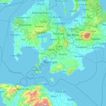
Name: Topografische Karte Batangas, Höhe, Relief.
Ort: Batangas, Calabarzon, Philippines (13.47385 120.34778 14.24889 121.60997)
Durchschnittliche Höhe: 126 m
Minimale Höhe: -3 m
Maximale Höhe: 2.532 m
Spenden
Rüste dich für dein nächstes Abenteuer:
Als Amazon-Partner verdient diese Website an qualifizierten Käufen, ohne zusätzliche Kosten für Sie.
Andere topografische Karten
Klicken Sie auf eine Karte, um ihre Topografie, ihre Höhe und ihr Relief anzuzeigen.
Quezon City
Founded as a pueblo by Saint Pedro Bautista in 1590, San Francisco del Monte may be considered Quezon City's oldest district. The original land area of the old town of San Francisco del Monte was approximately2.5 square kilometres (1.0 sq mi) and covered parts of what is currently known as Project 7 and 8 and…
Durchschnittliche Höhe: 57 m
Spenden
Rüste dich für dein nächstes Abenteuer:
Als Amazon-Partner verdient diese Website an qualifizierten Käufen, ohne zusätzliche Kosten für Sie.
Montalban
Philippines > Rizal > Rodriguez
Rodriguez is generally very rough in topography, with 83% of its total land area composed of upland areas, hills and mountain ranges. The remaining 17% low-lying terrain and rolling lands are found at the south-western portion of the municipality, along with the northern portions of the Municipality of San…
Durchschnittliche Höhe: 99 m
Spenden
Rüste dich für dein nächstes Abenteuer:
Als Amazon-Partner verdient diese Website an qualifizierten Käufen, ohne zusätzliche Kosten für Sie.
Bacolod
Bacólod (English: Bacolod), is derived from bakólod (Old Spelling: bacólod), the Old Hiligaynon (Old Ilonggo) (Old Spelling: Ylongo and Ilongo) word for a "hill, turtle, mound, rise, hillock, down, any small eminence or elevation", since the resettlement was founded on a stony, hilly area, now the barangay…
Durchschnittliche Höhe: 49 m
Baguio
In 1903, Filipinos, Japanese and Chinese workers were hired to build Kennon Road, the first road directly connecting Baguio with the lowlands of La Union and Pangasinan. Before this, the only road to Benguet was Naguilian Road, and it was largely a horse trail at higher elevations. Camp John Hay was…
Durchschnittliche Höhe: 881 m
Spenden
Rüste dich für dein nächstes Abenteuer:
Als Amazon-Partner verdient diese Website an qualifizierten Käufen, ohne zusätzliche Kosten für Sie.
Spenden
Rüste dich für dein nächstes Abenteuer:
Als Amazon-Partner verdient diese Website an qualifizierten Käufen, ohne zusätzliche Kosten für Sie.
Tagaytay
The southern and eastern portions of Tagaytay are covered by hills and mountains which is generally forests, pine trees and open grasslands. The city lies along Tagaytay Ridge, a ridge stretching about 32 kilometres (20 mi) from Mount Batulao in the west to Mount Sungay in the east with elevations averaging…
Durchschnittliche Höhe: 229 m
Malolos
Malolos is relatively flat of about 0.81% to a gently sloping of 2.17%. The slope of the land descends towards west, southwest to southern direction. The highest land elevation is at about 6.0 meters above sea level while the lowest is only half a meter below sea level. A network of natural waterways and…
Durchschnittliche Höhe: 6 m
Spenden
Rüste dich für dein nächstes Abenteuer:
Als Amazon-Partner verdient diese Website an qualifizierten Käufen, ohne zusätzliche Kosten für Sie.
Spenden
Rüste dich für dein nächstes Abenteuer:
Als Amazon-Partner verdient diese Website an qualifizierten Käufen, ohne zusätzliche Kosten für Sie.
Spenden
Rüste dich für dein nächstes Abenteuer:
Als Amazon-Partner verdient diese Website an qualifizierten Käufen, ohne zusätzliche Kosten für Sie.
Quezon Municipal Plaza , Nueva Vizcaya
Philippines > Nueva Vizcaya > Quezon
Durchschnittliche Höhe: 296 m
Spenden
Rüste dich für dein nächstes Abenteuer:
Als Amazon-Partner verdient diese Website an qualifizierten Käufen, ohne zusätzliche Kosten für Sie.
Valencia
Philippines > Negros Oriental > Valencia
Valencia occupies an area of 14,749 hectares (36,450 acres), 35% of which are classified as plains. The town is 65% mountainous, with elevation averaging from 200 to 500 metres (660 to 1,640 ft) above sea level, with the top of Mount Talinis at an elevation of 1,903 metres (6,243 ft) along the municipal…
Durchschnittliche Höhe: 250 m
Spenden
Rüste dich für dein nächstes Abenteuer:
Als Amazon-Partner verdient diese Website an qualifizierten Käufen, ohne zusätzliche Kosten für Sie.
Cabadbaran
Philippines > Agusan del Norte
It is 29 kilometres (18 mi) from Butuan. It is generally flat with rolling hills and swamplands in its western part. The highest of all mountains in the Caraga region, Mount Hilong-Hilong (with an altitude of 2,012 metres (6,601 ft) above sea level), rises in this city.
Durchschnittliche Höhe: 179 m
Mandaluyong
Another claims that the Spaniards named the place based on the report of a navigator named Acapulco, who saw the rolling hills frequently being lashed at by daluyong (“big waves from the sea”). This seems to confirm traditional pre-Hispanic stories that giant waves from the sea would meet the adjoining…
Durchschnittliche Höhe: 33 m
Spenden
Rüste dich für dein nächstes Abenteuer:
Als Amazon-Partner verdient diese Website an qualifizierten Käufen, ohne zusätzliche Kosten für Sie.
Spenden
Rüste dich für dein nächstes Abenteuer:
Als Amazon-Partner verdient diese Website an qualifizierten Käufen, ohne zusätzliche Kosten für Sie.
San Juan
"San Juan" is a contraction of the city's traditional name of "San Juan del Monte" (lit. 'Saint John of the Mountain'). As with numerous other places in the Philippines, the name combines a patron saint and a toponym; in this case Saint John the Baptist with the locale's hilly terrain and relatively higher…
Durchschnittliche Höhe: 35 m
Spenden
Rüste dich für dein nächstes Abenteuer:
Als Amazon-Partner verdient diese Website an qualifizierten Käufen, ohne zusätzliche Kosten für Sie.
Spenden
Rüste dich für dein nächstes Abenteuer:
Als Amazon-Partner verdient diese Website an qualifizierten Käufen, ohne zusätzliche Kosten für Sie.
Lake Sebu
The placid lake of Lake Sebu can be found in Allah Valley near the municipality of Surallah, South Cotabato. Surrounded by rolling hills and mountains covered with thick rain forest, the lake has an area of 361.124 hectares (892.36 acres), with an elevation of approximately 1,000 metres (3,300 ft).
Durchschnittliche Höhe: 750 m
Sindangan
Philippines > Zamboanga del Norte
Since its elevation to a municipality in 1936, people from Luzon and the Visayas continued migrating to Sindangan to settle together with their families and built businesses. That is why aside from the Subanens, there are Sindanganons whose origins are from Bohol, Cebu, Samar, Leyte, Negros, Bicol, Pampanga,…
Durchschnittliche Höhe: 30 m
Spenden
Rüste dich für dein nächstes Abenteuer:
Als Amazon-Partner verdient diese Website an qualifizierten Käufen, ohne zusätzliche Kosten für Sie.
Marawi
Marawi is located upon the shores of Lake Lanao.[6] It is primarily inhabited by the Maranao people. The city is also called the "summer capital of the south" due to its higher elevation and cooler climate,[7] a nickname it shares with Malaybalay.[8][better source needed]
Durchschnittliche Höhe: 707 m
Enrile
Enrile is bounded by hills and mountains on both North and West. Area with low elevation is about 20 meters above sea level at the Eastern part which lies close to the river boundaries. The highest elevation is found Northwest which is approximately 800 meters above sea level.
Durchschnittliche Höhe: 45 m
Spenden
Rüste dich für dein nächstes Abenteuer:
Als Amazon-Partner verdient diese Website an qualifizierten Käufen, ohne zusätzliche Kosten für Sie.
Spenden
Rüste dich für dein nächstes Abenteuer:
Als Amazon-Partner verdient diese Website an qualifizierten Käufen, ohne zusätzliche Kosten für Sie.
Spenden
Rüste dich für dein nächstes Abenteuer:
Als Amazon-Partner verdient diese Website an qualifizierten Käufen, ohne zusätzliche Kosten für Sie.
Spenden
Rüste dich für dein nächstes Abenteuer:
Als Amazon-Partner verdient diese Website an qualifizierten Käufen, ohne zusätzliche Kosten für Sie.
Angeles
Sapangbato is the largest barangay in Angeles in terms of territory, with a total land area of 104,694 sq. meters and a population of 11,262. Located northwest of Angeles near Clark Freeport Zone, it is identified as the barangay in Angeles with the highest elevation of 750 feet above sea level. It is home to…
Durchschnittliche Höhe: 128 m
Spenden
Rüste dich für dein nächstes Abenteuer:
Als Amazon-Partner verdient diese Website an qualifizierten Käufen, ohne zusätzliche Kosten für Sie.
Spenden
Rüste dich für dein nächstes Abenteuer:
Als Amazon-Partner verdient diese Website an qualifizierten Käufen, ohne zusätzliche Kosten für Sie.
Spenden
Rüste dich für dein nächstes Abenteuer:
Als Amazon-Partner verdient diese Website an qualifizierten Käufen, ohne zusätzliche Kosten für Sie.
Spenden
Rüste dich für dein nächstes Abenteuer:
Als Amazon-Partner verdient diese Website an qualifizierten Käufen, ohne zusätzliche Kosten für Sie.
Spenden
Rüste dich für dein nächstes Abenteuer:
Als Amazon-Partner verdient diese Website an qualifizierten Käufen, ohne zusätzliche Kosten für Sie.
Spenden
Rüste dich für dein nächstes Abenteuer:
Als Amazon-Partner verdient diese Website an qualifizierten Käufen, ohne zusätzliche Kosten für Sie.
Spenden
Rüste dich für dein nächstes Abenteuer:
Als Amazon-Partner verdient diese Website an qualifizierten Käufen, ohne zusätzliche Kosten für Sie.