Geolokalisieren

Topografische Karte Pali Village

Klicken Sie auf die Karte, um die Höhe anzuzeigen.

Über diese Karte

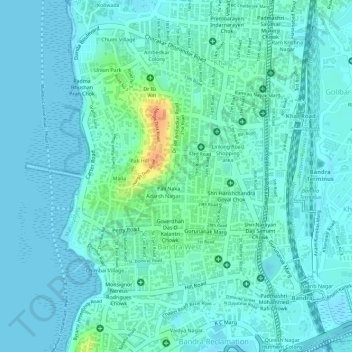
Name: Topografische Karte Pali Village, Höhe, Relief.

Ort: Pali Village, Adarsh Nagar, H/W Ward, Zone 3, Mumbai, Mumbai Suburban, Maharashtra, 400050, India (19.05373 72.81999 19.07373 72.83999)

Durchschnittliche Höhe: 9 m

Minimale Höhe: -2 m

Maximale Höhe: 45 m

Andere topografische Karten

Klicken Sie auf eine Karte, um ihre Topografie, ihre Höhe und ihr Relief anzuzeigen.

Mumbai

India > Maharashtra > Mumbai

Mumbai is on a narrow peninsula on the southwest of Salsette Island, which lies between the Arabian Sea to the west, Thane Creek to the east and Vasai Creek to the north. Mumbai's suburban district occupies most of the island. Navi Mumbai is east of Thane Creek and Thane is north of Vasai Creek. Mumbai…

Durchschnittliche Höhe: 18 m

Mithi River

India > Maharashtra > Mumbai

Durchschnittliche Höhe: 19 m

K/W Ward

India > Maharashtra > Mumbai

Durchschnittliche Höhe: 11 m

Joggers Park

India > Maharashtra > Mumbai

Durchschnittliche Höhe: 6 m

Powai Lake

India > Maharashtra > Mumbai

Durchschnittliche Höhe: 46 m

Ghatkopar Hill

India > Maharashtra > Mumbai

Durchschnittliche Höhe: 50 m

Juhu Beach

India > Maharashtra > Mumbai

Durchschnittliche Höhe: 4 m

Ganesh Talav

India > Maharashtra > Mumbai

Durchschnittliche Höhe: 11 m

Sion Fort

India > Maharashtra > Mumbai

Durchschnittliche Höhe: 6 m

Observation Post (Chotta Kashmir)

India > Maharashtra > Mumbai

Durchschnittliche Höhe: 49 m

Manori Aum Beach

India > Maharashtra > Mumbai

Durchschnittliche Höhe: 3 m

Girgaum Chowpatty Beach

India > Maharashtra > Mumbai

Durchschnittliche Höhe: 11 m

B Ward

India > Maharashtra > Mumbai

Durchschnittliche Höhe: 7 m

Shivaji Park

India > Maharashtra > Mumbai

Durchschnittliche Höhe: 7 m

M/E Ward

India > Maharashtra > Mumbai

Durchschnittliche Höhe: 15 m

Vakola Nala

India > Maharashtra > Mumbai

Durchschnittliche Höhe: 8 m

Heritage Gardens

India > Maharashtra > Mumbai

Durchschnittliche Höhe: 51 m

Dharavi

India > Maharashtra > Mumbai

Durchschnittliche Höhe: 6 m

Mumbai

India > Maharashtra > Mumbai

Mumbai is on a narrow peninsula on the southwest of Salsette Island, which lies between the Arabian Sea to the west, Thane Creek to the east and Vasai Creek to the north. Mumbai's suburban district occupies most of the island. Navi Mumbai is east of Thane Creek and Thane is north of Vasai Creek. Mumbai…

Durchschnittliche Höhe: 18 m

Sion Talav

India > Maharashtra > Mumbai

Durchschnittliche Höhe: 6 m

Dharavi

India > Maharashtra > Mumbai

Durchschnittliche Höhe: 6 m

Late Shri D.K. Sandu Udyan

India > Maharashtra > Mumbai

Durchschnittliche Höhe: 10 m

Late Shri D.K. Sandu Udyan

India > Maharashtra > Mumbai

Durchschnittliche Höhe: 10 m

K/E Ward

India > Maharashtra > Mumbai

Durchschnittliche Höhe: 21 m

Dharavi

India > Maharashtra > Mumbai

Durchschnittliche Höhe: 6 m

Dharavi

India > Maharashtra > Mumbai

Durchschnittliche Höhe: 6 m

Vakola Nala

India > Maharashtra > Mumbai

Durchschnittliche Höhe: 8 m

Dharavi

India > Maharashtra > Mumbai

Durchschnittliche Höhe: 6 m

Rüste dich für dein nächstes Abenteuer:

🔦Outdoor Taschenlampen - Leistungsstarke Lampen für Nacht und Notfälle
🧤Warme Fausthandschuhe - Bestmöglicher Schutz gegen Erfrierungen an den Fingern
🏞️Wanderkarten - Regionale Karten für Tourenplanung
🏕️Trekkingzelte - Leichte Zelte für Rucksacktouren
🛋️Outdoor Hängematte - Leicht und kompakt für eine Pause zwischen Bäumen

Als Amazon-Partner verdient diese Website an qualifizierten Käufen, ohne zusätzliche Kosten für Sie.