
Topografische Karte Chebika du Jérid
Interaktive Karte
Klicken Sie auf die Karte, um die Höhe anzuzeigen.
Über diese Karte
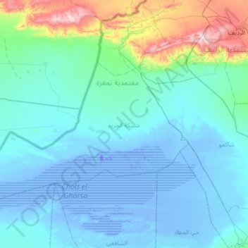
Name: Topografische Karte Chebika du Jérid, Höhe, Relief.
Durchschnittliche Höhe: 109 m
Minimale Höhe: -35 m
Maximale Höhe: 899 m
Andere topografische Karten
Klicken Sie auf eine Karte, um ihre Topografie, ihre Höhe und ihr Relief anzuzeigen.
Chott el-Gharsa
Tunisie > Gouvernorat Tozeur > Chafai Ech-Cherif
Chott el-Gharsa, Chafai Ech-Cherif, Délégation Nefta, Gouvernorat Tozeur, Tunisie
Durchschnittliche Höhe: 41 m
Nefta
Tunisie > Gouvernorat Tozeur > Es-Seni
Nefta, Es-Seni, Délégation Nefta, Gouvernorat Tozeur, 2240, Tunisie
Durchschnittliche Höhe: 75 m
Degache
Tunisie > Gouvernorat Tozeur > Degach Sud
Degache, Degach Sud, Délégation Degache, Gouvernorat Tozeur, 2260, Tunisie
Durchschnittliche Höhe: 60 m
Délégation Degache
Délégation Degache, Gouvernorat Tozeur, Tunisie
Durchschnittliche Höhe: 72 m
Délégation Hazoua
Délégation Hazoua, Gouvernorat Tozeur, Tunisie
Durchschnittliche Höhe: 29 m
Sabaa Abar
Sabaa Abar, Délégation Degache, Gouvernorat Tozeur, Tunisie
Durchschnittliche Höhe: 23 m
Ain El Karma
Ain El Karma, Délégation Tameghza, Gouvernorat Tozeur, Tunisie
Durchschnittliche Höhe: 540 m
El Keitna
El Keitna, Délégation Tozeur, Gouvernorat Tozeur, Tunisie
Durchschnittliche Höhe: 57 m
Tameghza
Tunisie > Gouvernorat Tozeur > Tameghza
Tameghza, Délégation Tameghza, Gouvernorat Tozeur, Tunisie
Durchschnittliche Höhe: 342 m