
Topografische Karte Pershing County
Interaktive Karte
Klicken Sie auf die Karte, um die Höhe anzuzeigen.
Über diese Karte
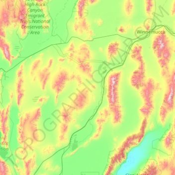
Name: Topografische Karte Pershing County, Höhe, Relief.
Ort: Pershing County, Nevada, États-Unis d'Amérique (39.99816 -119.33852 40.96106 -117.30002)
Durchschnittliche Höhe: 1.449 m
Minimale Höhe: 1.029 m
Maximale Höhe: 2.962 m
Andere topografische Karten
Klicken Sie auf eine Karte, um ihre Topografie, ihre Höhe und ihr Relief anzuzeigen.
Carlin
États-Unis d'Amérique > Nevada > Elko County
Carlin, Elko County, Nevada, 89822, États-Unis d'Amérique
Durchschnittliche Höhe: 1.522 m
North Las Vegas
États-Unis d'Amérique > Nevada > Clark County
North Las Vegas, Clark County, Nevada, États-Unis d'Amérique
Durchschnittliche Höhe: 684 m
Spring Valley
États-Unis d'Amérique > Nevada > Clark County
Spring Valley, Clark County, Nevada, États-Unis d'Amérique
Durchschnittliche Höhe: 736 m
Churchill County
États-Unis d'Amérique > Nevada
Churchill County, Nevada, États-Unis d'Amérique
Durchschnittliche Höhe: 1.476 m
Las Vegas
États-Unis d'Amérique > Nevada > Clark County
Las Vegas, Clark County, Nevada, États-Unis d'Amérique
Durchschnittliche Höhe: 756 m
White Pine County
États-Unis d'Amérique > Nevada
White Pine County, Nevada, États-Unis d'Amérique
Durchschnittliche Höhe: 2.049 m