
Spenden
Rüste dich für dein nächstes Abenteuer:
Als Amazon-Partner verdient diese Website an qualifizierten Käufen, ohne zusätzliche Kosten für Sie.
Topografische Karte Somerset
Klicken Sie auf die Karte, um die Höhe anzuzeigen.
Spenden
Rüste dich für dein nächstes Abenteuer:
Als Amazon-Partner verdient diese Website an qualifizierten Käufen, ohne zusätzliche Kosten für Sie.
Über diese Karte
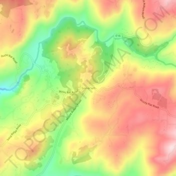
Name: Topografische Karte Somerset, Höhe, Relief.
Durchschnittliche Höhe: 642 m
Minimale Höhe: 442 m
Maximale Höhe: 808 m
Spenden
Rüste dich für dein nächstes Abenteuer:
Als Amazon-Partner verdient diese Website an qualifizierten Käufen, ohne zusätzliche Kosten für Sie.
Andere topografische Karten
Klicken Sie auf eine Karte, um ihre Topografie, ihre Höhe und ihr Relief anzuzeigen.
El Dorado Hills
United States > California > El Dorado County > Cameron Park
El Dorado Hills (EDH), as defined by the 2010 census-designated place (CDP), is at the western border of El Dorado County, between the City of Folsom and the unincorporated community of Cameron Park. The northern limits of the CDP are Folsom Lake and the South Fork of the American River, where river rafters…
Durchschnittliche Höhe: 254 m
South Lake Tahoe
United States > California > El Dorado County
According to the United States Census Bureau, the city has a total area of 16.6 square miles (43 km2), of which 10.2 square miles (26 km2) is land and 6.4 square miles (17 km2), or 38.80%, is water. Its elevation is about 6,237 feet (1,901 m) above sea level.
Durchschnittliche Höhe: 1.979 m
Cameron Park
United States > California > El Dorado County > Cameron Park
Cameron Park is situated in an interior chaparral zone or brush zone just east of the Central Valley. It is the closest population center to the Pine Hill Ecological Reserve. Native vegetation includes an abundance of redbud and manzanita bushes, and brush in general. Where treed the native trees are primarily…
Durchschnittliche Höhe: 409 m
El Dorado Hills
United States > California > El Dorado County > Cameron Park
El Dorado Hills (EDH), as defined by the 2020 census-designated place (CDP), is at the western border of El Dorado County, between the City of Folsom and the unincorporated community of Cameron Park. The northern limits of the CDP are Folsom Lake and the South Fork of the American River, where river rafters…
Durchschnittliche Höhe: 250 m
Spenden
Rüste dich für dein nächstes Abenteuer:
Als Amazon-Partner verdient diese Website an qualifizierten Käufen, ohne zusätzliche Kosten für Sie.
Placerville
United States > California > El Dorado County
The region east of Placerville, popularly known as Apple Hill and Pleasant Valley, is becoming a center for wine production. The wine region is officially designated as the El Dorado AVA. The largest wineries in the area are Boeger, Lava Cap and Madrona, but most of the 30 plus wineries surrounding Placerville…
Durchschnittliche Höhe: 586 m
Shingle Springs
United States > California > El Dorado County > Cameron Park
Durchschnittliche Höhe: 433 m
Pollock Pines
United States > California > El Dorado County > Pollock Pines
Pollock Pines is a census-designated place (CDP) in El Dorado County, California, United States. It is part of the Sacramento–Arden-Arcade–Roseville Metropolitan Statistical Area. Pollock Pines lies at an elevation of 3,980 feet (1,210 m) in the Sierra Nevada. The population was 6,871 at the 2010 census,…
Durchschnittliche Höhe: 1.118 m
Spenden
Rüste dich für dein nächstes Abenteuer:
Als Amazon-Partner verdient diese Website an qualifizierten Käufen, ohne zusätzliche Kosten für Sie.
Placerville
United States > California > El Dorado County
The region east of Placerville, popularly known as Apple Hill and Pleasant Valley, is becoming a center for wine production. The wine region is officially designated as the El Dorado AVA. The largest wineries in the area are Boeger, Lava Cap and Madrona, but most of the 30 plus wineries surrounding Placerville…
Durchschnittliche Höhe: 587 m
El Dorado Hills
United States > California > El Dorado County > Cameron Park
El Dorado Hills (EDH), as defined by the 2010 census-designated place (CDP), is at the western border of El Dorado County, between the City of Folsom and the unincorporated community of Cameron Park. The northern limits of the CDP are Folsom Lake and the South Fork of the American River, where river rafters…
Durchschnittliche Höhe: 252 m
Spenden
Rüste dich für dein nächstes Abenteuer:
Als Amazon-Partner verdient diese Website an qualifizierten Käufen, ohne zusätzliche Kosten für Sie.
Cameron Park
United States > California > El Dorado County
Cameron Park is situated in an interior chaparral zone or brush zone just east of the Central Valley. It is the closest population center to the Pine Hill Ecological Reserve. Native vegetation includes an abundance of redbud and manzanita bushes, and brush in general. Where treed the native trees are primarily…
Durchschnittliche Höhe: 409 m
South Lake Tahoe
United States > California > El Dorado County
According to the United States Census Bureau, the city has a total area of 16.6 square miles (43 km2), of which 10.2 square miles (26 km2) is land and 6.4 square miles (17 km2), or 38.80%, is water. Its elevation is about 6,237 feet (1,901 m) above sea level.
Durchschnittliche Höhe: 1.979 m
Eldorado National Forest
United States > California > El Dorado County
The forest ranges in elevation from 1,000 feet (300 m) in the foothills to more than 10,000 feet (3,000 m) above sea level along the Sierra crest. The mountainous topography is broken by the steep canyons of the Mokelumne, Cosumnes, American, and Rubicon rivers. Plateaus of generally moderate relief are…
Durchschnittliche Höhe: 1.807 m
Spenden
Rüste dich für dein nächstes Abenteuer:
Als Amazon-Partner verdient diese Website an qualifizierten Käufen, ohne zusätzliche Kosten für Sie.
Diamond Springs
United States > California > El Dorado County
Diamond Springs (formerly, Diamond Spring and Diamond) is a census-designated place (CDP) in El Dorado County, California, United States. It is part of the Sacramento–Arden-Arcade–Roseville Metropolitan Statistical Area. The population was 11,037 at the 2010 census, up from 4,888 at the 2000 census. The…
Durchschnittliche Höhe: 531 m
Placerville
United States > California > El Dorado County
The region east of Placerville, popularly known as Apple Hill and Pleasant Valley, is becoming a center for wine production. The wine region is officially designated as the El Dorado AVA. The largest wineries in the area are Boeger, Lava Cap and Madrona, but most of the 30 plus wineries surrounding Placerville…
Durchschnittliche Höhe: 586 m
Cameron Park
United States > California > El Dorado County
Cameron Park is situated in an interior chaparral zone or brush zone just east of the Central Valley. It is the closest population center to the Pine Hill Ecological Reserve. Native vegetation includes an abundance of redbud and manzanita bushes, and brush in general. Where treed the native trees are primarily…
Durchschnittliche Höhe: 409 m
Stumpy Meadows Reservoir
United States > California > El Dorado County
Durchschnittliche Höhe: 1.334 m
Spenden
Rüste dich für dein nächstes Abenteuer:
Als Amazon-Partner verdient diese Website an qualifizierten Käufen, ohne zusätzliche Kosten für Sie.
Cameron Park
United States > California > El Dorado County > Cameron Park
Cameron Park is situated in an interior chaparral zone or brush zone just east of the Central Valley. It is the closest population center to the Pine Hill Ecological Reserve. Native vegetation includes an abundance of redbud and manzanita bushes, and brush in general. Where treed the native trees are primarily…
Durchschnittliche Höhe: 409 m
El Dorado Hills
United States > California > El Dorado County > Folsom
El Dorado Hills (EDH), as defined by the 2010 census-designated place (CDP), is at the western border of El Dorado County, between the City of Folsom and the unincorporated community of Cameron Park. The northern limits of the CDP are Folsom Lake and the South Fork of the American River, where river rafters…
Durchschnittliche Höhe: 243 m
South Lake Tahoe
United States > California > El Dorado County
According to the United States Census Bureau, the city has a total area of 16.6 square miles (43 km2), of which 10.2 square miles (26 km2) is land and 6.4 square miles (17 km2), or 38.80%, is water. Its elevation is about 6,237 feet (1,901 m) above sea level.
Durchschnittliche Höhe: 1.979 m