
Topografische Karte Saint Petersburg
Interaktive Karte
Klicken Sie auf die Karte, um die Höhe anzuzeigen.
Über diese Karte
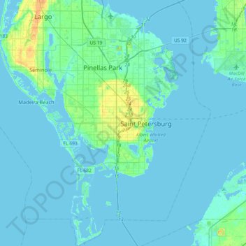
Name: Topografische Karte Saint Petersburg, Höhe, Relief.
Durchschnittliche Höhe: 3 m
Minimale Höhe: -2 m
Maximale Höhe: 29 m
Andere topografische Karten
Klicken Sie auf eine Karte, um ihre Topografie, ihre Höhe und ihr Relief anzuzeigen.
Pasadena
United States > Florida > Pinellas County > Saint Petersburg
Pasadena, Saint Petersburg, Pinellas County, Florida, 33707, United States
Durchschnittliche Höhe: 7 m
The Jungle
United States > Florida > Pinellas County > Saint Petersburg
The Jungle, Saint Petersburg, Pinellas County, Florida, 33744, United States
Durchschnittliche Höhe: 5 m
Lakewood Estates
United States > Florida > Pinellas County > Saint Petersburg
Lakewood Estates, Saint Petersburg, Pinellas County, Florida, 33712, United States
Durchschnittliche Höhe: 7 m
Louise Lake
United States > Florida > Pinellas County > Saint Petersburg
Louise Lake, Disston Heights, Saint Petersburg, Pinellas County, Florida, United States
Durchschnittliche Höhe: 17 m
Broadwater
United States > Florida > Pinellas County > Saint Petersburg
Broadwater, Saint Petersburg, Pinellas County, Florida, 33711, United States
Durchschnittliche Höhe: 5 m
Shore Acres
United States > Florida > Pinellas County > Saint Petersburg > Shore Acres
Shore Acres, Saint Petersburg, Pinellas County, Florida, 33703, United States
Durchschnittliche Höhe: 2 m