
Topografische Karte Steve Tshwete Ward 5
Interaktive Karte
Klicken Sie auf die Karte, um die Höhe anzuzeigen.
Über diese Karte
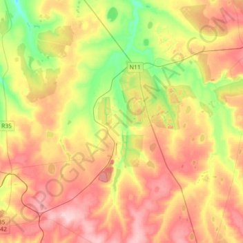
Name: Topografische Karte Steve Tshwete Ward 5, Höhe, Relief.
Durchschnittliche Höhe: 1.624 m
Minimale Höhe: 1.535 m
Maximale Höhe: 1.710 m
Andere topografische Karten
Klicken Sie auf eine Karte, um ihre Topografie, ihre Höhe und ihr Relief anzuzeigen.
Middelburg
South Africa > Mpumalanga > Nkangala > Steve Tshwete Local Municipality
Middelburg, Steve Tshwete Local Municipality, Nkangala, Mpumalanga, 1050, South Africa
Durchschnittliche Höhe: 1.493 m
Loskop Dam
South Africa > Mpumalanga > Nkangala > Steve Tshwete Local Municipality
Loskop Dam, Steve Tshwete Local Municipality, Nkangala, Mpumalanga, South Africa
Durchschnittliche Höhe: 1.211 m
Pullenshope
South Africa > Mpumalanga > Nkangala > Steve Tshwete Local Municipality
Pullenshope, Steve Tshwete Local Municipality, Nkangala, Mpumalanga, South Africa
Durchschnittliche Höhe: 1.613 m
Middelburg Dam
South Africa > Mpumalanga > Nkangala > Steve Tshwete Local Municipality
Middelburg Dam, Steve Tshwete Local Municipality, Nkangala, Mpumalanga, South Africa
Durchschnittliche Höhe: 1.543 m
Steve Tshwete Ward 16
South Africa > Mpumalanga > Nkangala > Steve Tshwete Local Municipality
Steve Tshwete Ward 16, Steve Tshwete Local Municipality, Nkangala, Mpumalanga, 1080, South Africa
Durchschnittliche Höhe: 1.476 m