
Topografische Karte Waldoboro
Interaktive Karte
Klicken Sie auf die Karte, um die Höhe anzuzeigen.
Über diese Karte
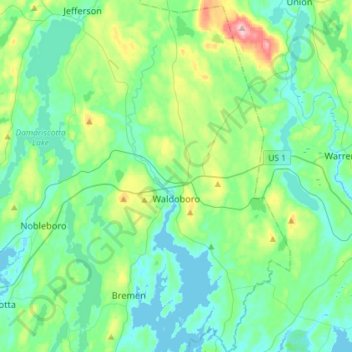
Name: Topografische Karte Waldoboro, Höhe, Relief.
Ort: Waldoboro, Lincoln County, Maine, 04572, United States (44.00468 -69.45017 44.21227 -69.28203)
Durchschnittliche Höhe: 40 m
Minimale Höhe: -3 m
Maximale Höhe: 193 m
Andere topografische Karten
Klicken Sie auf eine Karte, um ihre Topografie, ihre Höhe und ihr Relief anzuzeigen.
Westport Island
United States > Maine > Lincoln County > Westport Island
Westport Island, Lincoln County, Maine, United States
Durchschnittliche Höhe: 21 m
Trevett
United States > Maine > Lincoln County > Boothbay
Trevett, Boothbay, Lincoln County, Maine, 04571, United States
Durchschnittliche Höhe: 13 m
Monhegan Island Plantation
United States > Maine > Lincoln County
Monhegan Island Plantation, Lincoln County, Maine, 04852, United States
Durchschnittliche Höhe: 0 m
Boothbay
United States > Maine > Lincoln County
Boothbay, Lincoln County, Maine, United States
Durchschnittliche Höhe: 9 m
South Bristol
United States > Maine > Lincoln County
South Bristol, Lincoln County, Maine, United States
Durchschnittliche Höhe: 13 m
Nobleboro
United States > Maine > Lincoln County
Nobleboro, Lincoln County, Maine, 04555, United States
Durchschnittliche Höhe: 40 m