
Topografische Karte Goodview
Interaktive Karte
Klicken Sie auf die Karte, um die Höhe anzuzeigen.
Über diese Karte
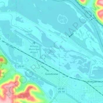
Name: Topografische Karte Goodview, Höhe, Relief.
Ort: Goodview, Winona County, Minnesota, 55959, United States (44.05223 -91.76048 44.09373 -91.68979)
Durchschnittliche Höhe: 212 m
Minimale Höhe: 191 m
Maximale Höhe: 367 m
Andere topografische Karten
Klicken Sie auf eine Karte, um ihre Topografie, ihre Höhe und ihr Relief anzuzeigen.
Pine Creek
United States > Minnesota > Winona County
Pine Creek, Winona County, Minnesota, United States
Durchschnittliche Höhe: 355 m
Whitewater State Park
United States > Minnesota > Winona County
Whitewater State Park, Winona County, Minnesota, United States
Durchschnittliche Höhe: 324 m
Altura
United States > Minnesota > Winona County
Altura, Winona County, Minnesota, United States
Durchschnittliche Höhe: 355 m
Winona
United States > Minnesota > Winona County
Winona, Winona County, Minnesota, 55987, United States
Durchschnittliche Höhe: 272 m