
Spenden
Rüste dich für dein nächstes Abenteuer:
Als Amazon-Partner verdient diese Website an qualifizierten Käufen, ohne zusätzliche Kosten für Sie.
Topografische Karte Shenley
Klicken Sie auf die Karte, um die Höhe anzuzeigen.
Spenden
Rüste dich für dein nächstes Abenteuer:
Als Amazon-Partner verdient diese Website an qualifizierten Käufen, ohne zusätzliche Kosten für Sie.
Über diese Karte
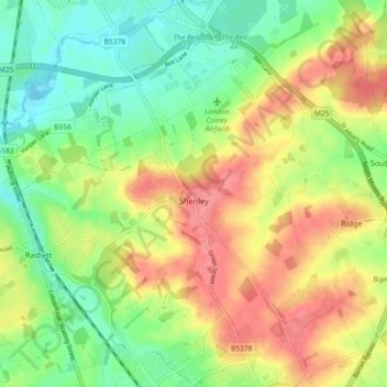
Name: Topografische Karte Shenley, Höhe, Relief.
Ort: Shenley, Hertsmere, Hertfordshire, England, United Kingdom (51.66522 -0.30200 51.72137 -0.24758)
Durchschnittliche Höhe: 97 m
Minimale Höhe: 63 m
Maximale Höhe: 137 m
Spenden
Rüste dich für dein nächstes Abenteuer:
Als Amazon-Partner verdient diese Website an qualifizierten Käufen, ohne zusätzliche Kosten für Sie.
Andere topografische Karten
Klicken Sie auf eine Karte, um ihre Topografie, ihre Höhe und ihr Relief anzuzeigen.
Spenden
Rüste dich für dein nächstes Abenteuer:
Als Amazon-Partner verdient diese Website an qualifizierten Käufen, ohne zusätzliche Kosten für Sie.
Bushey
United Kingdom > England > Hertfordshire > Hertsmere
Bushey is a town in the Hertsmere borough of Hertfordshire in the East of England. It had a population of 25,328 in the 2011 census, rising to 28,416 in the 2021 census, an increase of 12.19%. This makes Bushey the second most populated town in Hertsmere. Bushey Heath is a large neighbourhood south east of…
Durchschnittliche Höhe: 88 m
Bentley Heath
United Kingdom > England > Hertfordshire > Hertsmere > Potters Bar
Durchschnittliche Höhe: 105 m
Elstree
United Kingdom > England > Hertfordshire > Hertsmere
In 1723, topographer John Norden noted in his book Speculum Britanniae, that in the county of Hartfordshire [sic] was one "Elstre or Eglestre". In an earlier edition, he writes.
Durchschnittliche Höhe: 105 m
Spenden
Rüste dich für dein nächstes Abenteuer:
Als Amazon-Partner verdient diese Website an qualifizierten Käufen, ohne zusätzliche Kosten für Sie.
Merry Hill
United Kingdom > England > Hertfordshire > Hertsmere > Bushey Heath > Merry Hill
Durchschnittliche Höhe: 98 m
Well End
United Kingdom > England > Hertfordshire > Hertsmere > Borehamwood > Shenley
Durchschnittliche Höhe: 108 m
Bushey
United Kingdom > England > Hertfordshire > Hertsmere
Bushey is a town in the Hertsmere borough of Hertfordshire in the East of England. It had a population of 25,328 in the 2011 census, rising to 28,416 in the 2021 census, an increase of 12.19%. This makes Bushey the second most populated town in Hertsmere. Bushey Heath is a large neighbourhood south east of…
Durchschnittliche Höhe: 88 m
Spenden
Rüste dich für dein nächstes Abenteuer:
Als Amazon-Partner verdient diese Website an qualifizierten Käufen, ohne zusätzliche Kosten für Sie.
Patchetts Green
United Kingdom > England > Hertfordshire > Hertsmere > Aldenham
Durchschnittliche Höhe: 83 m
Elstree
United Kingdom > England > Hertfordshire > Hertsmere
In 1723, topographer John Norden noted in his book Speculum Britanniae, that in the county of Hartfordshire [sic] was one "Elstre or Eglestre". In an earlier edition, he writes.
Durchschnittliche Höhe: 105 m
Spenden
Rüste dich für dein nächstes Abenteuer:
Als Amazon-Partner verdient diese Website an qualifizierten Käufen, ohne zusätzliche Kosten für Sie.