
Spenden
Rüste dich für dein nächstes Abenteuer:
Als Amazon-Partner verdient diese Website an qualifizierten Käufen, ohne zusätzliche Kosten für Sie.
Topografische Karte Winnipeg
Klicken Sie auf die Karte, um die Höhe anzuzeigen.
Spenden
Rüste dich für dein nächstes Abenteuer:
Als Amazon-Partner verdient diese Website an qualifizierten Käufen, ohne zusätzliche Kosten für Sie.
Winnipeg
Winnipeg lies at the bottom of the Red River Valley, a flood plain with an extremely flat topography. It is on the eastern edge of the Canadian Prairies in Western Canada and is known as the "Gateway to the West". Winnipeg is bordered by tallgrass prairie to the west and south and the aspen parkland to the northeast, although most of the native prairie grasses have been removed for agriculture and urbanization. It is relatively close to many large Canadian Shield lakes and parks, as well as Lake Winnipeg (the Earth's 11th largest freshwater lake). Winnipeg has North America's largest extant mature urban elm forest. The city has an area of 464.08 km2 (179.18 sq mi).
Spenden
Rüste dich für dein nächstes Abenteuer:
Als Amazon-Partner verdient diese Website an qualifizierten Käufen, ohne zusätzliche Kosten für Sie.
Über diese Karte
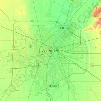
Name: Topografische Karte Winnipeg, Höhe, Relief.
Ort: Winnipeg, Manitoba, R3C 3Z3, Canada (49.73554 -97.29846 50.05554 -96.97846)
Durchschnittliche Höhe: 236 m
Minimale Höhe: 222 m
Maximale Höhe: 272 m
Spenden
Rüste dich für dein nächstes Abenteuer:
Als Amazon-Partner verdient diese Website an qualifizierten Käufen, ohne zusätzliche Kosten für Sie.