
Topografische Karte Hathersage
Klicken Sie auf die Karte, um die Höhe anzuzeigen.
Hathersage
The Fat Boys Stanage Struggle is a popular local fell race that starts in Hathersage, altitude 91 metres (299 ft), and routes up to and along Stanage Edge to High Neb, 458 metres (1,503 ft), before returning to the village 367 metres (1,204 ft) below.
Über diese Karte
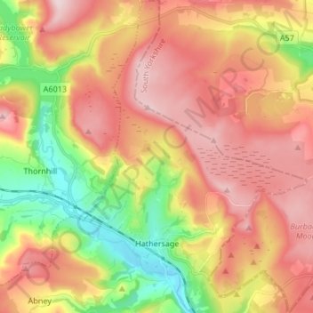
Name: Topografische Karte Hathersage, Höhe, Relief.
Durchschnittliche Höhe: 311 m
Minimale Höhe: 136 m
Maximale Höhe: 462 m
Andere topografische Karten
Klicken Sie auf eine Karte, um ihre Topografie, ihre Höhe und ihr Relief anzuzeigen.
Hallam Moors
United Kingdom > England > Derbyshire > Derbyshire Dales > Hathersage
Durchschnittliche Höhe: 368 m
Slaley
United Kingdom > England > Derbyshire > Derbyshire Dales > Matlock > Bonsall CP
Durchschnittliche Höhe: 263 m
Bolehill
United Kingdom > England > Derbyshire > Derbyshire Dales > Wirksworth CP
Durchschnittliche Höhe: 220 m
Riber Castle
United Kingdom > England > Derbyshire > Derbyshire Dales > Matlock > Starkholmes
Durchschnittliche Höhe: 169 m
Parsley Hay
United Kingdom > England > Derbyshire > Derbyshire Dales > Parsley Hay
Durchschnittliche Höhe: 334 m
Arbor Low
United Kingdom > England > Derbyshire > Derbyshire Dales > Parsley Hay
Durchschnittliche Höhe: 342 m
Newhaven
United Kingdom > England > Derbyshire > Derbyshire Dales > Biggin
Durchschnittliche Höhe: 332 m
Two Dales
United Kingdom > England > Derbyshire > Derbyshire Dales > Darley Dale CP > Darley Hillside
Durchschnittliche Höhe: 189 m
Starkholmes
United Kingdom > England > Derbyshire > Derbyshire Dales > Matlock
Durchschnittliche Höhe: 175 m
Farley Wood
United Kingdom > England > Derbyshire > Derbyshire Dales > Matlock
Durchschnittliche Höhe: 255 m
Magpie Mine
United Kingdom > England > Derbyshire > Derbyshire Dales > Ashford in the Water CP
Durchschnittliche Höhe: 303 m
Catcliff Wood
United Kingdom > England > Derbyshire > Derbyshire Dales > Bakewell CP
Durchschnittliche Höhe: 173 m
Gang Mine
United Kingdom > England > Derbyshire > Derbyshire Dales > Cromford CP
Durchschnittliche Höhe: 226 m
Taddington Dale
United Kingdom > England > Derbyshire > Derbyshire Dales > Brushfield CP
Durchschnittliche Höhe: 281 m
Cressbrook Dale
United Kingdom > England > Derbyshire > Derbyshire Dales > Litton CP > Litton Mill
Durchschnittliche Höhe: 286 m
Stanton-in-Peak
United Kingdom > England > Derbyshire > Derbyshire Dales
Durchschnittliche Höhe: 175 m
Curbar Edge
United Kingdom > England > Derbyshire > Derbyshire Dales > Curbar CP
Durchschnittliche Höhe: 252 m
Hathersage Booths
United Kingdom > England > Derbyshire > Derbyshire Dales > Hathersage
Durchschnittliche Höhe: 260 m
Stanage Plantation
United Kingdom > England > Derbyshire > Derbyshire Dales > Hathersage
Durchschnittliche Höhe: 360 m
Darley Hillside
United Kingdom > England > Derbyshire > Derbyshire Dales
Durchschnittliche Höhe: 187 m
Housley
United Kingdom > England > Derbyshire > Derbyshire Dales > Eyam CP
Durchschnittliche Höhe: 303 m
Black Rocks
United Kingdom > England > Derbyshire > Derbyshire Dales > Cromford CP
Durchschnittliche Höhe: 199 m
Padley Gorge
United Kingdom > England > Derbyshire > Derbyshire Dales > Grindleford
Durchschnittliche Höhe: 316 m
Alsop en le Dale
United Kingdom > England > Derbyshire > Derbyshire Dales
Durchschnittliche Höhe: 277 m
Horseshoe Quarry
United Kingdom > England > Derbyshire > Derbyshire Dales > Eyam CP
Durchschnittliche Höhe: 293 m
Curbar Edge
United Kingdom > England > Derbyshire > Derbyshire Dales > Calver Sough
Durchschnittliche Höhe: 251 m
Monsal Head
United Kingdom > England > Derbyshire > Derbyshire Dales > Cressbrook > Monsal Head
Durchschnittliche Höhe: 231 m
Breamfield
United Kingdom > England > Derbyshire > Derbyshire Dales > Wirksworth CP > Breamfield
Durchschnittliche Höhe: 213 m
Coplow Dale
United Kingdom > England > Derbyshire > Derbyshire Dales > Little Hucklow
Durchschnittliche Höhe: 333 m
Stoke Brook
United Kingdom > England > Derbyshire > Derbyshire Dales > Calver Sough
Durchschnittliche Höhe: 197 m
Calver Sough
United Kingdom > England > Derbyshire > Derbyshire Dales > Calver Sough
Durchschnittliche Höhe: 218 m
Longcliffe
United Kingdom > England > Derbyshire > Derbyshire Dales > Brassington CP
Durchschnittliche Höhe: 299 m
Lathkill Dale
United Kingdom > England > Derbyshire > Derbyshire Dales > Youlgreave
Durchschnittliche Höhe: 269 m
Yarncliff Wood
United Kingdom > England > Derbyshire > Derbyshire Dales > Grindleford
Durchschnittliche Höhe: 260 m
Longstone Edge
United Kingdom > England > Derbyshire > Derbyshire Dales > Rowland
Durchschnittliche Höhe: 290 m
Breamfield
United Kingdom > England > Derbyshire > Derbyshire Dales > Wirksworth CP
Durchschnittliche Höhe: 213 m
Padley Gorge
United Kingdom > England > Derbyshire > Derbyshire Dales > Grindleford
Durchschnittliche Höhe: 316 m
Wirksworth Moor
United Kingdom > England > Derbyshire > Derbyshire Dales > Wirksworth CP
Durchschnittliche Höhe: 207 m
White Path Moss
United Kingdom > England > Derbyshire > Derbyshire Dales
Durchschnittliche Höhe: 371 m