
Topografische Karte Stellenbosch
Interaktive Karte
Klicken Sie auf die Karte, um die Höhe anzuzeigen.
Über diese Karte
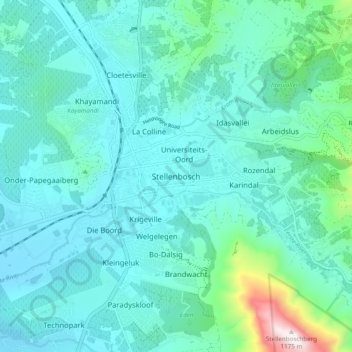
Name: Topografische Karte Stellenbosch, Höhe, Relief.
Durchschnittliche Höhe: 222 m
Minimale Höhe: 61 m
Maximale Höhe: 1.163 m
Stellenbosch is 53 km (33 mi) east of Cape Town via National Route N1. Stellenbosch is in a hilly region of the Cape Winelands, and is sheltered in a valley at an average elevation of 136 m (446 ft), flanked on the west by Papegaaiberg (Afrikaans: Parrot Mountain), which is actually a hill. To the south is Stellenbosch Mountain; to the east and southeast are the Jonkershoek, Drakenstein, and Simonsberg mountains. Die Tweeling Pieke (Afrikaans: The Twin Peaks) has an elevation of 1,494 m (4,902 ft); the highest point is Victoria Peak 1,590 m (5,220 ft). Jonkershoek Nature Reserve lies about 9 km (5.6 mi) east of Stellenbosch, and the Helderberg Nature Reserve is about 23 km (14 mi) south via provincial route R44. Just south of the Helderberg Nature Reserve is Strand, a seaside resort town. The soils of Stellenbosch range from dark alluvium to clay. This, combined with the well-drained, hilly terrain and Mediterranean climate, prove excellent for viticulture. Summers are dry and warm to hot, with some February and March days rising to over 40 °C (104 °F). Winters are cool, rainy and sometimes quite windy, with daytime temperatures averaging 16 °C (61 °F). Snow is usually seen a couple of times in winter on the surrounding mountains. Spring and autumn are colder seasons, when daytime temperatures hover in the 20s.
Andere topografische Karten
Klicken Sie auf eine Karte, um ihre Topografie, ihre Höhe und ihr Relief anzuzeigen.
Jamestown
South Africa > Western Cape > Cape Winelands District Municipality > Stellenbosch > Jamestown
Jamestown, Stellenbosch, Cape Winelands District Municipality, Western Cape, 7487, South Africa
Durchschnittliche Höhe: 140 m