
Topografische Karte Gruppo del Pomagagnon
Interaktive Karte
Klicken Sie auf die Karte, um die Höhe anzuzeigen.
Über diese Karte
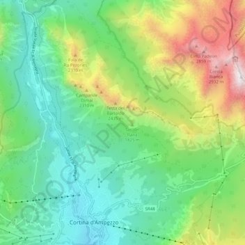
Name: Topografische Karte Gruppo del Pomagagnon, Höhe, Relief.
Durchschnittliche Höhe: 1.758 m
Minimale Höhe: 1.159 m
Maximale Höhe: 3.085 m
Pomagagnon is a mountain of the Dolomites in Belluno, northern Italy. It has an elevation of 2,450 metres (8,038 ft) and is the southernmost mountain of the Cristallo Group, towering 1,200 metres (3,937 ft) over the resort of Cortina d'Ampezzo. The mountain is part of the "Natural Park of the Ampezzo Dolomites".
Andere topografische Karten
Klicken Sie auf eine Karte, um ihre Topografie, ihre Höhe und ihr Relief anzuzeigen.
Falzarego Pass
Italy > Veneto > Belluno > Cortina d'Ampezzo
Falzarego Pass, Cortina d'Ampezzo, Belluno, Veneto, Italy
Durchschnittliche Höhe: 2.179 m
Pocol
Italy > Veneto > Belluno > Cortina d'Ampezzo
Pocol, Cortina d'Ampezzo, Belluno, Veneto, 32043, Italy
Durchschnittliche Höhe: 1.448 m
Cinque Torri
Italy > Veneto > Belluno > Cortina d'Ampezzo
Cinque Torri, Cortina d'Ampezzo, Belluno, Veneto, Italy
Durchschnittliche Höhe: 2.071 m